Detail View: Old Maps Collection: 禹跡圖
|
Barcode:
|
4687820500616
|
|
Title:
|
禹跡圖
|
|
Original Title:
|
禹跡圖
|
|
Contributor:
|
Anonymous
|
|
Category:
|
General Maps
|
|
Type:
|
Printed
|
|
Language:
|
Chinese
|
|
Create Year:
|
1903?
|
|
Format:
|
JPEG2000, 4747 × 5349, 3.8MB
|
|
Scale:
|
ca. 1:5,000,000
|
|
Physical Map Dimension (cm):
|
41 × 39
|
|
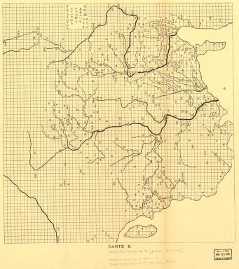
Note:
|
Stone rubbing dated 1903? One of the earliest stone maps, it consists of 5,110 grids, each grid is approximately 100 li. Original stone was engraved in Fuchang 7 nian, i.e. 1136 A.D. The stone is now in the Forest of Stone Steles Museum in Xi'an, China. Shows coast lines, Yellow River, Yangtze River and its branches, Tai Lake, Dongting Lake, and Fanyang Lake. Annotated in pencil: From Bull. de l'Ecole Française d'Extrème, Orient, vol. 3, 1903, facing page 214. On bottom of map: Carte B. Includes text.
|
|
Note:
|
This is an early old map depicted the world
|
|
Subject:
|
Rivers
|
|
Subject:
|
Rubbing
|
|
Geographic Area:
|
China
|
|
Pub Year:
|
1903?
|
|
Pub location:
|
France
|
|
Provenance:
|
Library of Congress Map Collections
|