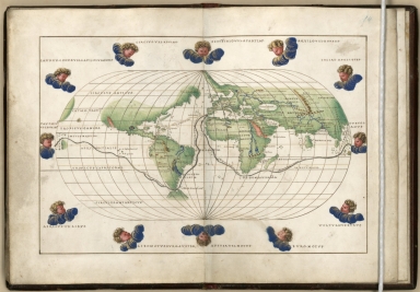
Detail View: Old Maps Collection: [A world map from Portolan atlas]
|
Barcode:
|
4687820500646
|
|
Title:
|
[A world map from Portolan atlas]
|
|
Original Title:
|
N/A
|
|
Contributor:
|
Agnese, Battista, active 16th century
|
|
Category:
|
Thematic Maps
|
|
Type:
|
Manuscripts
|
|
Language:
|
Latin
|
|
Create Year:
|
1542
|
|
Format:
|
JPEG2000, 5680 × 3960, 4.1MB
|
|
Scale:
|
Scale not given
|
|
Note:
|
Manuscript, pen and ink and watercolor, on vellum. Shows Magellan's route around the world and a route from Spain to Peru.
|
|
Note:
|
The author of this map was Battista Agnese, who worked in Venice between 1536 and 1564 and became one of the most important figures in Renaissance cartography.The most detailed maps show complete coasts, ports, and rivers and were the navigation aids of the day, but they do not generally represent inland features other than towns and cities.
|
|
Subject:
|
Early maps
|
|
Subject:
|
Voyages and travels
|
|
Subject:
|
World maps, Manuscript
|
|
Geographic Area:
|
World
|
|
Pub Title:
|
Portolan atlas
|
|
Pub Author:
|
Agnese, Battista, active 16th century
|
|
Pub Year:
|
1544 ca.
|
|
Pub location:
|
Venice
|
|
Provenance:
|
Library of Congress Map Collections
|