Detail View: Old Maps Collection: Portolan chart of the Mediterranean and connecting seas
|
Barcode:
|
4687820500612
|
|
Title:
|
Portolan chart of the Mediterranean and connecting seas
|
|
Original Title:
|
Portolan chart of the Mediterranean and connecting seas
|
|
Contributor:
|
Anonymous
|
|
Category:
|
Sea Charts
|
|
Type:
|
Manuscripts
|
|
Language:
|
English
|
|
Create Year:
|
1550?
|
|
Format:
|
JPEG2000, 3975 × 8615, 6.9MB
|
|
Scale:
|
ca. 1:10,000,000
|
|
Physical Map Dimension (cm):
|
50 × 19
|
|
Note:
|
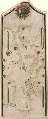
Portolan chart with seaport names given for all coastlines. Does not cover Black Sea. Title devised by cataloguer. Oriented with north to the right (indicated by fleurs-de-lys). Contains 11 compass roses in a circle centered on Sicily, 2 additional roses in Iberia, and rhumb lines connecting all roses and some central points without roses. Manuscript: pen-and-ink (brown) and dark watercolors. Includes 4 scale bars (unidentified) and a large compass rose at top (in neck of sheet) containing a drawing of the Madonna and Child.
|
|
Note:
|
This is an early old map depicted the world
|
|
Subject:
|
Nautical charts
|
|
Subject:
|
Seaports
|
|
Subject:
|
Maps, Manuscript
|
|
Geographic Area:
|
Mediterranean Sea
|
|
Pub Title:
|
Maps, Manuscript--Early works to 1800.
|
|
Pub Author:
|
Anonymous
|
|
Pub Year:
|
1550?
|
|
Provenance:
|
Library of Congress Map Collections
|