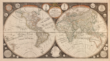
Detail View: Old Maps Collection: A new map of the world : with all the new discoveries by Capt. Cook and other navigators : ornamented with the Solar System, the eclipses of the sun, moon & planets &c.
|
Barcode:
|
4687820500607
|
|
Title:
|
A new map of the world : with all the new discoveries by Capt. Cook and other navigators : ornamented with the Solar System, the eclipses of the sun, moon & planets &c.
|
|
Original Title:
|
A new map of the world : with all the new discoveries by Capt. Cook and other navigators : ornamented with the Solar System, the eclipses of the sun, moon & planets &c.
|
|
Contributor:
|
Kitchen, T. (Thomas), Junior
|
|
Contributor:
|
Evans, John, active 1794-1799
|
|
Category:
|
Hemispheres
|
|
Type:
|
Printed
|
|
Language:
|
English
|
|
Create Year:
|
1799
|
|
Format:
|
JPEG2000, 12932 × 7224, 14.1MB
|
|
Scale:
|
ca. 1:50,000,000
|
|
Physical Map Dimension (cm):
|
79 × 112
|
|
Note:
|
Also shows lines of magnetic variation and marine wind-direction arrows. "Published as the Act directs, Aug't 1st 1799, by I. Evans, No. 41 Long Lane, West Smithfield." Originally printed on 2 sheets. Imperfect: Use-worn, fold-lined, wrinkled/missing small sections at edges, taped on verso at edges. Includes 12 circular diagrams of sun, moon, planets, and Solar System.
|
|
Note:
|
Macao was marked in the middle of Pearl River Estuary in this map.
|
|
Note:
|
Macao in World Maps
|
|
Subject:
|
Magnetic declination
|
|
Geographic Area:
|
World
|
|
Pub Author:
|
I. Evans
|
|
Pub Year:
|
1799
|
|
Pub location:
|
London
|
|
Provenance:
|
Library of Congress Map Collections
|