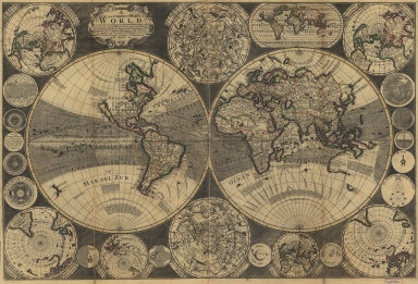
Detail View: Old Maps Collection: A new and correct map of the world : laid down according to the newest observations & discoveries in several different projections including the trade winds, monsoons, variation of the compass, and illustrated with a coelestial planisphere, the various systems of Ptolomy, Copernicus, and Tycho Brahe together with ye apearances of the planets &c.

|
Barcode:
|
4687820500606
|
|
Title:
|
A new and correct map of the world : laid down according to the newest observations & discoveries in several different projections including the trade winds, monsoons, variation of the compass, and illustrated with a coelestial planisphere, the various systems of Ptolomy, Copernicus, and Tycho Brahe together with ye apearances of the planets &c.
|
|
Original Title:
|
A new and correct map of the world : laid down according to the newest observations & discoveries in several different projections including the trade winds, monsoons, variation of the compass, and illustrated with a coelestial planisphere, the various systems of Ptolomy, Copernicus, and Tycho Brahe together with ye apearances of the planets &c.
|
|
Contributor:
|
Godson, W. (William)
|
|
Category:
|
Hemispheres
|
|
Type:
|
Printed
|
|
Language:
|
English
|
|
Create Year:
|
1702
|
|
Format:
|
JPEG2000, 11562 × 7879, 13.7MB
|
|
Scale:
|
Scale not given
|
|
Physical Map Dimension (cm):
|
65 × 96
|
|
Note:
|
Insets: The northern hemisphere upon the plane of the Equinoctial -- The northern coelestial hemisphere -- A projection of ye world upon equidistant meridians and parallels -- The northern hemisphere upon the plane of the Ecliptic -- The face of the moon -- Tycho system -- Sphæra recta -- Mercury -- The sun enlightning ye moon -- The southern hemisphere upon the plane of ye Ecliptic -- Jupiter with his 4 satellites / by Cassini -- The northern hemisphere upon the plane of ye horizon -- Saturn / by Cassini -- The southern coelestial hemisphere -- Mars / by Cassini -- The southern hemisphere upon the plane of ye horizon -- Venus / by Cassini -- The southern hemisphere upon the plane of Equinoct -- The sun enlightning the earth -- Copernicus system -- Ptolomy system -- The face of the sun / by F.A. Kircher.
|
|
Note:
|
Macao was marked in the middle of Pearl River Estuary in this map.
|
|
Note:
|
Macao in World Maps
|
|
Geographic Area:
|
World
|
|
Pub Year:
|
1702
|
|
Pub location:
|
London
|
|
Provenance:
|
Library of Congress Map Collections
|