Detail View: Old Maps Collection: China's claimed straight baselines
|
Barcode:
|
4687820500604
|
|
Title:
|
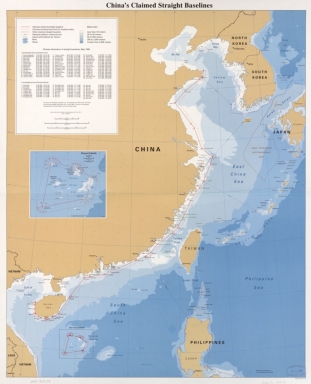
China's claimed straight baselines
|
|
Original Title:
|
China's claimed straight baselines
|
|
Contributor:
|
United States. Central Intelligence Agency
|
|
Category:
|
Sea Charts
|
|
Type:
|
Printed
|
|
Language:
|
English
|
|
Create Year:
|
1996
|
|
Format:
|
JPEG2000, 10839 × 13379, 31.8MB
|
|
Scale:
|
ca. 1:3,800,000
|
|
Physical Map Dimension (cm):
|
82 × 66
|
|
Note:
|
"802493 (R02169) 6-96." Relief shown by gradient tints. Includes 2 insets and list of Chinese declaration of straight baselines up to May 1996.
|
|
Note:
|
Macao was marked on coast of Pearl River Estuary in this map.
|
|
Note:
|
Macao in China Maps
|
|
Subject:
|
Territorial waters
|
|
Subject:
|
Continental shelf
|
|
Subject:
|
Contiguous zones (Law of the sea)
|
|
Subject:
|
Boundaries
|
|
Geographic Area:
|
China
|
|
Pub Author:
|
United States. Central Intelligence Agency
|
|
Pub Year:
|
1996
|
|
Pub location:
|
Washington, D.C.
|
|
Provenance:
|
Library of Congress Map Collections
|