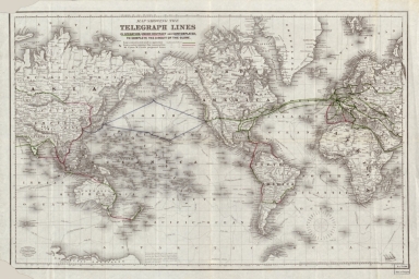
Detail View: Old Maps Collection: Map showing the telegraph lines in operation, under contract and contemplated, to complete the circuit of the globe
|
Barcode:
|
4687820500597
|
|
Title:
|
Map showing the telegraph lines in operation, under contract and contemplated, to complete the circuit of the globe
|
|
Contributor:
|
J.H. Colton & Co., author
|
|
Contributor:
|
G.W. & C.B. Colton & Co., publisher
|
|
Category:
|
Thematic Maps
|
|
Type:
|
Printed
|
|
Language:
|
English
|
|
Create Year:
|
[ca. 1871]
|
|
Format:
|
JPEG2000, 8082 × 5394, 9MB
|
|
Scale:
|
[ca. 1:75,000,000]. At equator (W 180°--E 180°/N 80°--S 68°).
|
|
Physical Map Dimension (cm):
|
39 x 60 cm, on sheet 54 x 69 cm
|
|
Note:
|
Samuel Morse (1791-1872) began his quest for an easier and more economical communication solution in the 1830's. Although a multiple-wire electromagnetic telegraph system was introduced in 1833, Morse developed a single wire system which could signal over a much longer distance and allowed operators to engage electrical current using a single key. His less costly system was adopted quickly by railroads and other businesses. Early cable route maps were often published in the cable history books. Later these maps were issued as promotional items by cable companies and government telecommunications authorities. This world map was first published in 1855, but it was re-issued ca. 1871, for the submarine cable from France to North America -laid in 1869- is shown as 'in operation'. This map shows lines constructed, under contract for construction, and proposed by Cyrus West Field (1819-1892) -an American businessman and financier who created the 'Atlantic Telegraph Company' and laid the first telegraph cable across the Atlantic Ocean in 1858.
|
|
Note:
|
Original map is printed with handcolored lines, 41 x 63 cm. The map is teared on both left corners.
|
|
Note:
|
There is a 32-point compass rose on the right bottom corner of the map with all the winds abbreviations.
|
|
Note:
|
In the map are depicted different routes identified with the name of the person who first sailed it and respective date.
|
|
Note:
|
Legend of the different lines underneath the title.
|
|
Note:
|
The map depicts both latitude and longitude.
|
|
Note:
|
Relief shown by hachures on land and bathymetric relief is show by isolines.
|
|
Note:
|
Map outlined in triple fillet.
|
|
Note:
|
Macao in World Maps
|
|
Note:
|
Macao in Routes
|
|
Subject:
|
Telegraph
|
|
Geographic Area:
|
World
|
|
Provenance:
|
Library of Congress
|
|
Provenance:
|
https://lccn.loc.gov/86692708
|
|
Provenance Call No.:
|
G3201.P92 1871
|
|
MUST holding:
|
https://must.primo.exlibrisgroup.com/permalink/853MUST_INST/171sgkf/alma991002923430605076
|