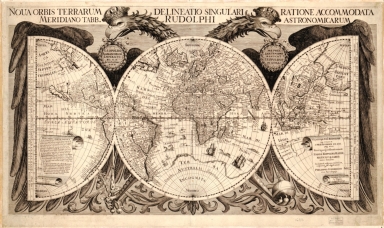
Detail View: Old Maps Collection: Noua orbis terrarum delineatio singulari ratione accommodata meridiano tabb. Rudolphi astronomicarum
|
Barcode:
|
4687820500581
|
|
Title:
|
Noua orbis terrarum delineatio singulari ratione accommodata meridiano tabb. Rudolphi astronomicarum
|
|
Original Title:
|
Noua orbis terrarum delineatio singulari ratione accommodata meridiano tabb. Rudolphi astronomicarum
|
|
Contributor:
|
Eckebrecht, Philipp, 1594-1667
|
|
Contributor:
|
Walch, J. P. (Johann Philipp)
|
|
Contributor:
|
Kepler, Johannes, 1571-1630
|
|
Category:
|
Hemispheres
|
|
Type:
|
Printed
|
|
Language:
|
Latin
|
|
Create Year:
|
1630
|
|
Format:
|
JPEG2000, 8491 × 5052, 6.5MB
|
|
Page No.:
|
1
|
|
Scale:
|
ca. 1:100,000,000
|
|
Physical Map Dimension (cm):
|
43 × 72
|
|
Note:
|
Prime meridian based on the astronomer Tycho Brahe's observatory in Denmark. Map drawn in three parts (left to right): 1 half-hemisphere (15 cm. radius), 1 hemisphere (29 cm. in diameter), and 1 half-hemisphere (15 cm. radius). Includes note and ill. of double eagle. Included in map folder: Folder (24 x 31 cm.) containing 7 photocopies from printed references and 1 letter of correspondence all describing this map. Also included is a section of the original map folder with a manuscript note regarding the date of publication and representation in Kepler's atlas. Mounted on cloth.
|
|
Note:
|
Macao was marked in the middle of Pearl River Estuary in this map.
|
|
Note:
|
Macao in World Maps
|
|
Reference:
|
Shirley, Rodney W. Mapping of the world. 1983, p. 358-9 Bricker, Charles. Landmarks of mapmaking. 1977, p. 252-3
|
|
Subject:
|
Earth
|
|
Geographic Area:
|
World
|
|
Relation Note:
|
Appears in Johannes Kepler's Tabvlae Rudolphinae. Ulm : Johannes Saur, 1627-30.
|
|
Pub Title:
|
Tabvlae Rudolphinae
|
|
Pub Author:
|
Kepler, Johannes, 1571-1630
|
|
Pub Year:
|
1630
|
|
Pub location:
|
Nuremberg
|
|
Provenance:
|
Library of Congress Map Collections
|
|
MUST holding:
|
http://10.20.100.239/record=b1347421
|