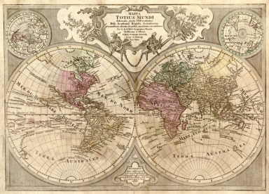
Detail View: Old Maps Collection: Mappa totius mundi : adornata juxta observationes dnn. academiae regalis scientiarum et nonnullorum aliorum secundum annotationes recentissimas

|
Barcode:
|
4687820500580
|
|
Title:
|
Mappa totius mundi : adornata juxta observationes dnn. academiae regalis scientiarum et nonnullorum aliorum secundum annotationes recentissimas
|
|
Original Title:
|
Mappa totius mundi : adornata juxta observationes dnn. academiae regalis scientiarum et nonnullorum aliorum secundum annotationes recentissimas
|
|
Contributor:
|
L'Isle, Guillaume de, 1675-1726
|
|
Contributor:
|
Lotter, Tobias Conrad, 1717-1777
|
|
Category:
|
Hemispheres
|
|
Type:
|
Printed
|
|
Language:
|
Latin
|
|
Create Year:
|
1775?
|
|
Format:
|
JPEG2000, 7864 × 5653, 6.7MB
|
|
Scale:
|
ca. 1:75,000,000
|
|
Physical Map Dimension (cm):
|
50 × 68
|
|
Note:
|
2 hemispheres each 32 cm. in diam. Includes note, ill., and ancillary maps of the northern hemisphere and southern hemisphere. Date principally obscured. Vertically fold-lined in half, mounted on cloth.
|
|
Note:
|
Macao was marked in the middle of Pearl River Estuary in this map.
|
|
Note:
|
Macao in World Maps
|
|
Subject:
|
Earth
|
|
Geographic Area:
|
World
|
|
Relation Note:
|
Appears in Tobias Conrad Lotter's Atlas géographique de cent et huit cartes générales et spéciales. Augsburg, 1778.
|
|
Pub Title:
|
Atlas géographique de cent et huit cartes générales et spéciales
|
|
Pub Author:
|
Prostat nunc in officina Tobiae Conradi Lotter
|
|
Pub Year:
|
1775?
|
|
Pub location:
|
Augsburg
|
|
Provenance:
|
Library of Congress Map Collections
|