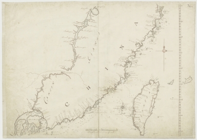
Detail View: Old Maps Collection: Kaart van een gedeelte der Chineese Zee en Kust, van Punta Lampa cao tot de Overveens Eilanden, het Eiland Formosa enz. Hierop komt mede voor de rivier van Canton, van den mond tot Fangsucis
|
Barcode:
|
4687820500578
|
|
Title:
|
Kaart van een gedeelte der Chineese Zee en Kust, van Punta Lampa cao tot de Overveens Eilanden, het Eiland Formosa enz. Hierop komt mede voor de rivier van Canton, van den mond tot Fangsucis
|
|
Contributor:
|
Anonymous
|
|
Category:
|
Sea Charts
|
|
Type:
|
Manuscripts
|
|
Language:
|
Dutch
|
|
Create Year:
|
17--
|
|
Format:
|
JPEG, 7028 × 5000, 15.7MB
|
|
Scale:
|
Scale not given
|
|
Note:
|
Macao and the surrounding islands were depicted in this map.
|
|
Note:
|
Macao and its Surroundings
|
|
Note:
|
Macao in Routes
|
|
Note:
|
Macao in China Maps
|
|
Geographic Area:
|
Zhejiang Sheng (China)
|
|
Geographic Area:
|
Fujian Sheng (China)
|
|
Geographic Area:
|
Guangdong Sheng (China)
|
|
Geographic Area:
|
Taiwan
|
|
Geographic Area:
|
Macao (China)
|
|
Provenance:
|
National Library of the Netherlands
|