Detail View: Old Maps Collection: China. Sheet 1. Eastern Coast. From Hui Ling San Harbour to Hong Kong
|
Barcode:
|
4687820500570
|
|
Title:
|
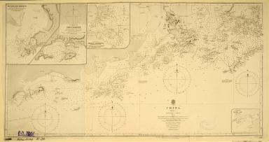
China. Sheet 1. Eastern Coast. From Hui Ling San Harbour to Hong Kong
|
|
Original Title:
|
China. Sheet 1. Eastern Coast. From Hui Ling San Harbour to Hong Kong
|
|
Contributor:
|
Great Britain. Admiralty, Hydrographic Office
|
|
Category:
|
Sea Charts
|
|
Type:
|
Printed
|
|
Language:
|
English
|
|
Create Year:
|
1883
|
|
Format:
|
JPEG, 7055 × 3730, 7.7MB
|
|
Scale:
|
[1:300 000]
|
|
Physical Map Dimension (cm):
|
30 x 58
|
|
Note:
|
"Surveyed by Capt. Sir E. Belcher, Cormmr. Bate, Lieut. Gordon, R.N. and Capt. D. Ross, I.N. With corrections and additions to 1881. Corrections to 1883, by Capt. Calder of the Chinese gunboat "Sui-tsing." Insets: Hui Ling San, Namo, and Macao Harbours and Shito Bay.
|
|
Note:
|
Macao and the surrounding islands were depicted in this map.
|
|
Note:
|
局部圖
|
|
Note:
|
Macao and its Surroundings
|
|
Note:
|
Macao in Routes
|
|
Subject:
|
Coasts
|
|
Subject:
|
Nautical charts
|
|
Geographic Area:
|
Macao (China)
|
|
Geographic Area:
|
Hong Kong (China)
|
|
Geographic Area:
|
Guangdong Sheng (China)
|
|
Pub Author:
|
Great Britain. Admiralty, Hydrographic Office
|
|
Pub Year:
|
1890
|
|
Pub location:
|
[London]
|
|
Provenance:
|
The National Archives (United Kingdom)
|