Detail View: Old Maps Collection: 南瞻部洲萬國掌菓之圖 = Nansenbushū bankoku shōka no zu
|
Barcode:
|
4687820500568
|
|
Title:
|
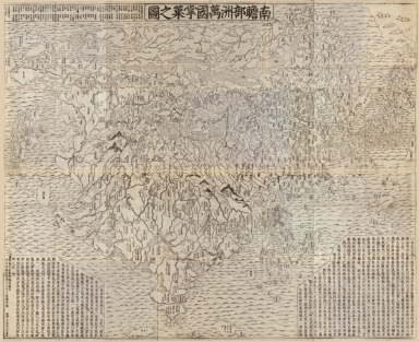
南瞻部洲萬國掌菓之圖 = Nansenbushū bankoku shōka no zu
|
|
Original Title:
|
南瞻部洲萬國掌菓之圖 = Nansenbushū bankoku shōka no zu
|
|
Contributor:
|
Sōshun, 1659?-1738
|
|
Category:
|
General Maps
|
|
Type:
|
Printed
|
|
Language:
|
Chinese
|
|
Create Year:
|
1710
|
|
Format:
|
JPEG2000, 17400 × 14208, 44.1MB
|
|
Page No.:
|
1
|
|
Scale:
|
Scale not given
|
|
Physical Map Dimension (cm):
|
113 × 143
|
|
Note:
|
Wood block print. Shows the world based on Buddhist literature from India and China. Title in Nihon kohan chizu shūsei: Nansenbushū bankoku shōka no zu. Posted on panel title: Bankoku shōka no zu.
|
|
Note:
|
Macao and the surrounding islands were depicted in this map.
|
|
Note:
|
Macao in World Maps
|
|
Subject:
|
Buddhism
|
|
Geographic Area:
|
World
|
|
Pub Title:
|
南瞻部洲萬國掌菓之圖 = Nansenbushū bankoku shōka no zu
|
|
Pub Author:
|
Sōshun, 1659?-1738
|
|
Pub Year:
|
[1710]
|
|
Pub location:
|
[Kyoto]
|
|
Provenance:
|
Library of Congress Map Collections
|