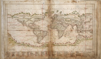
Detail View: Old Maps Collection: Albernaz coast map of world
|
Barcode:
|
4687820500566
|
|
Title:
|
Albernaz coast map of world
|
|
Original Title:
|
[Mapa detodo el mvndo]
|
|
Contributor:
|
Albernaz, João Teixeira, active 1602-1648
|
|
Contributor:
|
Attayde, Jeronimo de
|
|
Category:
|
Sea Charts
|
|
Type:
|
Manuscripts
|
|
Language:
|
Portuguese
|
|
Create Year:
|
1630
|
|
Format:
|
JPEG2000, 9200 × 5481, 7.6MB
|
|
Scale:
|
Scale not given
|
|
Physical Map Dimension (cm):
|
46 x 73
|
|
Note:
|
Orientation varies. Pen-and-ink and watercolor. Preface (4 p.) and last map created and added in 1692 by Don Francisco de Seixas y Lovera. Some staining and acid-transfer throughout. Bound in white paper in 1983.
|
|
Note:
|
Macao and the surrounding islands were depicted in this map.
|
|
Note:
|
Macao in World Maps
|
|
Reference:
|
LC Luso-Hispanic World, 8
|
|
Subject:
|
Nautical charts
|
|
Subject:
|
Harbors
|
|
Geographic Area:
|
World
|
|
Pub Title:
|
Taboas geraes de toda a navegação
|
|
Pub Year:
|
1630
|
|
Provenance:
|
Library of Congress Map Collections
|
|
MUST holding:
|
http://10.20.100.239/record=b1347448
|