Detail View: Old Maps Collection: [Asia]
|
Barcode:
|
3687800239892M
|
|
Title:
|
[Asia]
|
|
Original Title:
|
Noveno mapa delas costas dela Persia Asia, Tartaria y China
|
|
Other Title:
|
Mapas generales originales y unibersales des todo el orue con los puertos principales y fortalezas de Ambas Indias y una discripcion topographica de la region Austral Magallanica año de 1692
|
|
Other Title:
|
Albernaz coast map of Asia
|
|
Contributor:
|
Albernaz, João Teixeira, fl. 1602-1649, cartographer
|
|
Category:
|
Sea Charts
|
|
Type:
|
Manuscripts
|
|
Language:
|
Portuguese
|
|
Create Year:
|
[1630]
|
|
Format:
|
JPEG 2000, 9171 × 5544, 7.7MB
|
|
Page No.:
|
9
|
|
Scale:
|
Scale not given.
|
|
Physical Map Dimension (cm):
|
46 x 71 cm, on sheet 62 x 101 cm
|
|
Note:
|
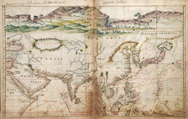
This map is from the work 'Taboas geraes de toda a navegaçaõ' by João Albernaz Teixeira a Portuguese cartographer son of Luís Teixeira also a cartographer. João Teixeira was probably the most remarkable Portuguese cartographer of the 17th century. This particular map depicts the Asian continent and the adjacent seas north of the Equator, including the western Pacific coast and the Indian Ocean. It is clear the special focus on the Portuguese colonies and trade routes. There is an emphasis on the south with little or no information up north. The coastlines and islands are heavily marked with place names with less emphasis on land interiors. Macao is written on land, in red -usually used for important places- on the right side of the Pearl River. Guangzhou is also written in red at the top of the Pearl River.
|
|
Note:
|
Original is a manuscript water coloured map by João Albernaz Teixeira in his work 'Taboas geraes de toda a navegação', 36 x 46 cm. The preface has the title 'Mapas generales originales y unibersales des todo el orue con los puertos principales y fortalezas de Ambas Indias y una discripcion topographica de la region Austral Magallanica año de 1692'
|
|
Note:
|
Title from provenance library.
|
|
Note:
|
There are watercolors of mountains, trees and rivers on the upper side. A building can be seen representing Jerusalem and there is a cross at Mount Sinai. On China there is a representation of the Great Wall -here named 'Muro da China'.
|
|
Note:
|
Table of leagues inside red double fillet at the bottom.
|
|
Note:
|
Relief shown pictorially.
|
|
Note:
|
Lands masses outlined in yellow with islands outlined in green and magenta.
|
|
Note:
|
Tropic of Capricorn and Equator lines in red. Latitude lines on both sides of the map in red and white interchangeably. Rhumb lines for the principal winds in black, the half-winds in red and quarter-winds in green.
|
|
Note:
|
Land masses written in black and water masses in red. Place names in both red and black.
|
|
Note:
|
Macao in Asia maps.
|
|
Reference:
|
Cortesão, A. Portugalliae Monumenta Cartographica, vol. 4, p. 111-116
|
|
Reference:
|
Pflederer, R.L. Catalogue of the Portolan Charts and Atlases in the Library of Congress, p. 94, 98
|
|
Reference:
|
Cortesão, J. Curso de História da Cartografia, Geografia das Fronteiras do Brasil e Mapoteconomia
|
|
Reference:
|
Dias, M. ; Botelho, H. Quatro séculos de imagens da Cartografia portuguesa = Four centuries of images from Portuguese Cartography
|
|
Subject:
|
Nautical charts
|
|
Subject:
|
Harbors
|
|
Geographic Area:
|
Asia
|
|
Geographic Area:
|
China
|
|
Geographic Area:
|
Africa, East
|
|
Geographic Area:
|
Iran
|
|
Geographic Area:
|
India
|
|
Geographic Area:
|
Ceylon
|
|
Geographic Area:
|
Malaysia
|
|
Geographic Area:
|
Indonesia
|
|
Geographic Area:
|
Vietnam
|
|
Geographic Area:
|
Borneo
|
|
Geographic Area:
|
Cambodia
|
|
Geographic Area:
|
Thailand
|
|
Geographic Area:
|
Myanmar
|
|
Geographic Area:
|
Paracel Islands
|
|
Geographic Area:
|
Philippines
|
|
Geographic Area:
|
Korea
|
|
Geographic Area:
|
Japan
|
|
Geographic Area:
|
Papua New Guinea
|
|
Relation Note:
|
[9]
|
|
Pub Title:
|
Taboas geraes de toda a navegaçaõ
|
|
Pub Author:
|
Albernaz, João Teixeira, fl. 1602-1649
|
|
Pub Year:
|
1630
|
|
Pub location:
|
[S.l.]
|
|
Provenance:
|
Library of Congress
|
|
Provenance:
|
https://lccn.loc.gov/78653638
|
|
Provenance Call No.:
|
G1015 .T4 1630 Vault
|
|
MUST holding:
|
https://must.primo.exlibrisgroup.com/permalink/853MUST_INST/reglfj/alma991000441309705076
|