Detail View: Old Maps Collection: 海疆洋界形勢圖.Part 2
|
Barcode:
|
4687820500560
|
|
Title:
|
海疆洋界形勢圖.Part 2
|
|
Original Title:
|
海疆洋界形勢圖.Part 2
|
|
Contributor:
|
Hummel, Arthur W. (Arthur William), 1884-1975
|
|
Category:
|
Sea Charts
|
|
Type:
|
Manuscripts
|
|
Language:
|
Chinese
|
|
Create Year:
|
1787-1801
|
|
Format:
|
JPEG2000, 19830 × 4163, 17.7MB
|
|
Scale:
|
Scale ca. 1:760,000
|
|
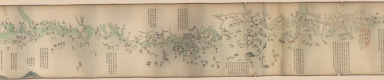
Note:
|
Oriented with north to the right. Pictorial map. Hummel purchase 1930, no. 8. Insets: Huan hai quan tu -- Qi sheng yan hai quan tu -- Qiongzhou tu -- Penghu tu -- Taiwan tu -- Taiwan hou shan tu. Includes text.
|
|
Note:
|
Macao and the surrounding islands were depicted in this map.
|
|
Subject:
|
Coasts
|
|
Geographic Area:
|
Hainan Sheng (China)
|
|
Geographic Area:
|
Eastern Hemisphere
|
|
Geographic Area:
|
Pʻeng-hu hsien (Taiwan)
|
|
Geographic Area:
|
Taiwan
|
|
Relation Note:
|
Part 1 : 4687820500559 ; Part 3 : 4687820500561 ; Part 4 : 4687820500562 ; Part 5 : 4687820500563 ; Part 6 : 4687820500564
|
|
Pub Title:
|
海疆洋界形勢圖
|
|
Pub Year:
|
[1787-1801]
|
|
Provenance:
|
Library of Congress Map Collections
|