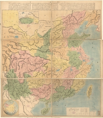
Detail View: Old Maps Collection: 皇朝直省輿地全圖 = Qing Empire's complete map of all provinces

|
Barcode:
|
4687820500545
|
|
Title:
|
皇朝直省輿地全圖 = Qing Empire's complete map of all provinces
|
|
Original Title:
|
皇朝直省輿地全圖 = Qing Empire's complete map of all provinces
|
|
Contributor:
|
Xujiahui tian zhu tang (Shanghai, China)
|
|
Category:
|
General Maps
|
|
Type:
|
Printed
|
|
Language:
|
Chinese
|
|
Create Year:
|
1887
|
|
Format:
|
JPEG2000, 15408 × 17612, 55.3MB
|
|
Scale:
|
Scale ca. 1:2,200,000
|
|
Physical Map Dimension (cm):
|
136 × 124
|
|
Note:
|
Shows administrative divisions of Qing Empire. Also shows the coasts and an area between the eastern parts of the Jiayuguan Pass and Tibet. Title supplied. Hand colored. Imprint stamped on. Prime meridian: Beijing. Includes text, location map, and inset of Xinjiang Sheng area.
|
|
Note:
|
Macao and the surrounding islands were depicted in this map.
|
|
Note:
|
Macao and its Surroundings
|
|
Note:
|
Macao in China Maps
|
|
Subject:
|
Administrative and political divisions
|
|
Geographic Area:
|
China
|
|
Pub Author:
|
Xujiahui tian zhu tang (Shanghai, China)
|
|
Pub Year:
|
1887
|
|
Pub location:
|
[Shanghai]
|
|
Provenance:
|
Library of Congress Map Collections
|