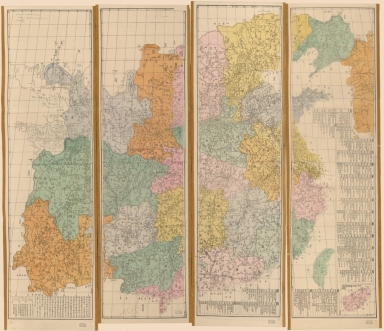
Detail View: Old Maps Collection: [皇朝直省與地全圖] = Qing Empire's complete map of all provinces
|
Barcode:
|
4687820500544
|
|
Title:
|
[皇朝直省與地全圖] = Qing Empire's complete map of all provinces
|
|
Original Title:
|
[皇朝直省與地全圖] = Qing Empire's complete map of all provinces
|
|
Contributor:
|
Li, Peilan
|
|
Category:
|
General Maps
|
|
Type:
|
Printed
|
|
Language:
|
Chinese
|
|
Create Year:
|
1896
|
|
Format:
|
JPEG2000, 17696 × 15287, 57.1MB
|
|
Scale:
|
Scale ca. 1:2,000,000
|
|
Physical Map Dimension (cm):
|
122 × 128
|
|
Note:
|
Title supplied. Wood block print, hand colored. Prime meridian: Beijing. Includes text, list of administrative divisions, and inset of Hainan Island.
|
|
Note:
|
Macao and the surrounding islands were depicted in this map.
|
|
Note:
|
Macao in China Maps
|
|
Geographic Area:
|
China
|
|
Pub Year:
|
1896
|
|
Pub location:
|
[China]
|
|
Provenance:
|
Library of Congress Map Collections
|