Detail View: Old Maps Collection: 廣東全省水陸與圖 = Map of the waterways and roads in Guangdong Province
|
Barcode:
|
4687820500541
|
|
Title:
|
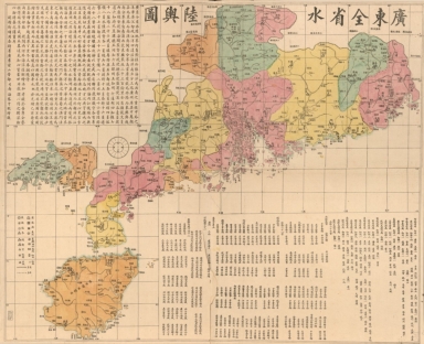
廣東全省水陸與圖 = Map of the waterways and roads in Guangdong Province
|
|
Original Title:
|
廣東全省水陸與圖 = Map of the waterways and roads in Guangdong Province
|
|
Contributor:
|
Li, Zhongpei, active 19th century
|
|
Category:
|
Thematic Maps
|
|
Type:
|
Printed
|
|
Language:
|
Chinese
|
|
Create Year:
|
1887?
|
|
Format:
|
JPEG2000, 14152 × 11530, 21.5MB
|
|
Scale:
|
Scale ca. 1:800,000
|
|
Physical Map Dimension (cm):
|
95 × 118
|
|
Note:
|
Wood block print, hand colored. Prime meridian: Beijing. Includes text and list of administrative divisions.
|
|
Note:
|
Macao and the surrounding islands were depicted in this map.
|
|
Note:
|
Macao in Routes
|
|
Note:
|
Macao and its Surroundings
|
|
Geographic Area:
|
Guangdong Sheng (China)
|
|
Pub Year:
|
1887?
|
|
Pub location:
|
[China]
|
|
Provenance:
|
Library of Congress Map Collections
|