Detail View: Old Maps Collection: 中華國恥地圖
|
Barcode:
|
4687820500538
|
|
Title:
|
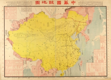
中華國恥地圖
|
|
Original Title:
|
中華國恥地圖
|
|
Contributor:
|
Hebei Sheng (China). Gong shang ting
|
|
Category:
|
Thematic Maps
|
|
Type:
|
Printed
|
|
Language:
|
Chinese
|
|
Create Year:
|
1929
|
|
Format:
|
JPEG2000, 12619 × 9119, 23.6MB
|
|
Scale:
|
Scale 1:6,400,000
|
|
Physical Map Dimension (cm):
|
68 × 98
|
|
Note:
|
Includes tables showing treaties signed by China, and harbors opened for foreign powers.
|
|
Note:
|
Macao and the surrounding islands were depicted in this map.
|
|
Note:
|
Macao in China Maps
|
|
Subject:
|
International relations
|
|
Subject:
|
Foreign relations
|
|
Geographic Area:
|
China
|
|
Pub Title:
|
中華國恥地圖
|
|
Pub Author:
|
Hebei Sheng (China). Gong shang ting
|
|
Pub Year:
|
1929
|
|
Pub location:
|
[Beijing]
|
|
Provenance:
|
Library of Congress Map Collections
|
|
MUST holding:
|
http://10.20.100.239/record=b1395975
|