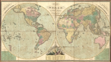
Detail View: Old Maps Collection: The world, on a globular projection, exhibiting the geographical researches of modern travellers & navigators

|
Barcode:
|
4687820500537
|
|
Title:
|
The world, on a globular projection, exhibiting the geographical researches of modern travellers & navigators
|
|
Original Title:
|
The world, on a globular projection, exhibiting the geographical researches of modern travellers & navigators
|
|
Contributor:
|
Vance, D. H. (David H.)
|
|
Category:
|
Hemispheres
|
|
Type:
|
Printed
|
|
Language:
|
English
|
|
Create Year:
|
1826
|
|
Format:
|
JPEG2000, 19215 × 10812, 29.1MB
|
|
Scale:
|
Scale approximately 1:40,000,000. At equator (W 180°--E 180°/N 90°--S 90°)
|
|
Physical Map Dimension (cm):
|
90 × 162
|
|
Note:
|
Includes statistics and illustrations of the world's highest mountains and longest rivers by continents.
|
|
Note:
|
Macao and the surrounding islands were depicted in this map.
|
|
Note:
|
Macao in World Maps
|
|
Subject:
|
Earth (Planet)
|
|
Geographic Area:
|
World
|
|
Pub Author:
|
Published by Anthony Finley
|
|
Pub Year:
|
1826
|
|
Pub location:
|
Philadelphia
|
|
Provenance:
|
Library of Congress Map Collections
|