Detail View: Old Maps Collection: 廣東全圖 = Complete map of Guangdong Province
|
Barcode:
|
4687820500536
|
|
Title:
|
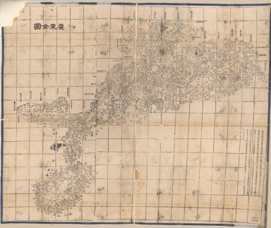
廣東全圖 = Complete map of Guangdong Province
|
|
Original Title:
|
廣東全圖 = Complete map of Guangdong Province
|
|
Contributor:
|
湖北省 (中國). 官書局
|
|
Category:
|
General Maps
|
|
Type:
|
Printed
|
|
Language:
|
Chinese
|
|
Create Year:
|
1864
|
|
Format:
|
JPEG2000, 13026 × 10962, 30.1MB
|
|
Scale:
|
ca. 1:1,000,000
|
|
Physical Map Dimension (cm):
|
92 × 108
|
|
Note:
|
Wood block print. One of 26 maps in "Da Qing yi tong yu di quan tu" which was compiled in 1864. Includes text and distance list.
|
|
Note:
|
Macao and the surrounding islands were depicted in this map.
|
|
Note:
|
Macao and its Surroundings
|
|
Geographic Area:
|
Guangdong Sheng (China)
|
|
Geographic Area:
|
Hainan Sheng (China)
|
|
Geographic Area:
|
Macao (China)
|
|
Pub Title:
|
大清一統輿地全圖
|
|
Pub Author:
|
湖北省 (中國). 官書局
|
|
Pub Year:
|
[1864]
|
|
Pub location:
|
Wuchang
|
|
Provenance:
|
Library of Congress Map Collections
|
|
MUST holding:
|
http://10.20.100.239/record=b1390034
|