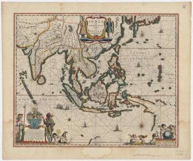
Detail View: Old Maps Collection: Blaeu map of Southeast Asia and the surrounding areas
|
Barcode:
|
4687820500534
|
|
Title:
|
Blaeu map of Southeast Asia and the surrounding areas
|
|
Original Title:
|
India quae Orientalis dicitur et insulae adiacentes
|
|
Contributor:
|
Blaeu, Willem Janszoon, 1571-1638
|
|
Category:
|
Sea Charts
|
|
Type:
|
Printed
|
|
Language:
|
Latin
|
|
Create Year:
|
1635
|
|
Format:
|
JPEG, 5992 × 5000, 16.1MB
|
|
Scale:
|
[ca. 1:17,700,000]
|
|
Physical Map Dimension (cm):
|
42 × 52
|
|
Note:
|
Includes dedication cartouche. Scale in German, Spanish, English, and French miles.
|
|
Note:
|
Macao and the surrounding islands were depicted in this map.
|
|
Note:
|
Macao in East Indies Maps
|
|
Subject:
|
Nautical charts
|
|
Geographic Area:
|
South Asia
|
|
Geographic Area:
|
Southeast Asia
|
|
Relation Note:
|
From: Frederik de Wit. Dutch sea atlas. Amsterdam, 1654. [sheet 11].
|
|
Pub Title:
|
Dutch sea atlas
|
|
Pub Author:
|
Wit, Frederik de
|
|
Pub Year:
|
1654
|
|
Pub location:
|
Amsterdam
|
|
Provenance:
|
Harvard Map Collection - Harvard College Library
|
|
MUST holding:
|
http://10.20.100.239/record=b1389966
|