Detail View: Old Maps Collection: 大清廿三省與地全圖 ; 附朝鮮州道與地圖 = Complete map of the twenty-three provinces of the great Qing Dynasty with a provincial map of Korea
|
Barcode:
|
4687820500527
|
|
Title:
|
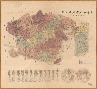
大清廿三省與地全圖 ; 附朝鮮州道與地圖 = Complete map of the twenty-three provinces of the great Qing Dynasty with a provincial map of Korea
|
|
Original Title:
|
大清廿三省與地全圖 ; 附朝鮮州道與地圖 = Complete map of the twenty-three provinces of the great Qing Dynasty with a provincial map of Korea
|
|
Contributor:
|
Anonymous
|
|
Category:
|
General Maps
|
|
Type:
|
Printed
|
|
Language:
|
Chinese
|
|
Create Year:
|
1885
|
|
Format:
|
JPEG2000, 7353 × 6725, 10MB
|
|
Scale:
|
Scale ca. 1:7,500,000
|
|
Physical Map Dimension (cm):
|
56 × 61
|
|
Note:
|
Wood block print, hand colored. Oriented with north toward the upper right. Shows provinces of China, Taiwan, Korea, and part of Manchuria. Includes text, distance chart, and inset.
|
|
Note:
|
Macao and the surrounding islands were depicted in this map.
|
|
Note:
|
Macao in China Maps
|
|
Geographic Area:
|
China
|
|
Geographic Area:
|
Korea
|
|
Pub Title:
|
大清廿三省與地全圖 ; 附朝鮮州道與地圖 = Complete map of the twenty-three provinces of the great Qing Dynasty with a provincial map of Korea
|
|
Pub Author:
|
Anonymous
|
|
Pub Year:
|
after 1885
|
|
Pub location:
|
[China]
|
|
Provenance:
|
Library of Congress Map Collections
|