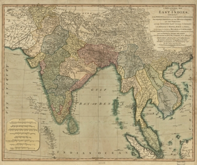
Detail View: Old Maps Collection: A new general map of the East Indies : exhibiting in the Peninsula on this side of the Ganges, or Hindoostan, the several partitions of the Mogul's Empire ; and the dominions of the English East India Company in the provinces of Bengal, Bahar, Orixa, as well as upon the coasts of Malabar and Coromandel ; with the French and Dutch possessions according to the peace of 1783 : and in the peninsula beyond the Ganges, the kingdoms of Assam, Cashar, Aua, Aracan, Mien, Pegu, Siam, Lao and Cambodia, &c.

|
Barcode:
|
4687820500526
|
|
Title:
|
A new general map of the East Indies : exhibiting in the Peninsula on this side of the Ganges, or Hindoostan, the several partitions of the Mogul's Empire ; and the dominions of the English East India Company in the provinces of Bengal, Bahar, Orixa, as well as upon the coasts of Malabar and Coromandel ; with the French and Dutch possessions according to the peace of 1783 : and in the peninsula beyond the Ganges, the kingdoms of Assam, Cashar, Aua, Aracan, Mien, Pegu, Siam, Lao and Cambodia, &c.
|
|
Original Title:
|
A new general map of the East Indies : exhibiting in the Peninsula on this side of the Ganges, or Hindoostan, the several partitions of the Mogul's Empire ; and the dominions of the English East India Company in the provinces of Bengal, Bahar, Orixa, as well as upon the coasts of Malabar and Coromandel ; with the French and Dutch possessions according to the peace of 1783 : and in the peninsula beyond the Ganges, the kingdoms of Assam, Cashar, Aua, Aracan, Mien, Pegu, Siam, Lao and Cambodia, &c.
|
|
Contributor:
|
Jefferys, Thomas, -1771
|
|
Contributor:
|
Rennell, James, 1742-1830
|
|
Category:
|
General Maps
|
|
Type:
|
Printed
|
|
Language:
|
English
|
|
Create Year:
|
1794
|
|
Format:
|
JPEG2000, 8481 × 7141, 10.5MB
|
|
Scale:
|
Scale [ca. 1:7,250,000] (E067°25'--E130°00'/N30°00'--N00°00')
|
|
Physical Map Dimension (cm):
|
57 × 69
|
|
Note:
|
Macao and the surrounding islands were depicted in this map.
|
|
Note:
|
Macao in Asia Maps;Macao in East Indies Maps
|
|
Note:
|
Macao in Asia Maps
|
|
Geographic Area:
|
Southeast Asia
|
|
Geographic Area:
|
East Indies
|
|
Pub Author:
|
Laurie & Whittle
|
|
Pub Year:
|
1794
|
|
Pub location:
|
London
|
|
Provenance:
|
Library of Congress Map Collections
|