Detail View: Old Maps Collection: Carte de l'entrée de la riviere de Canton dans la Chine
|
Barcode:
|
4687820500010
|
|
Title:
|
Carte de l'entrée de la riviere de Canton dans la Chine
|
|
Contributor:
|
Bellin, Jacques-Nicolas, 1703-1772, cartographer
|
|
Category:
|
Sea Charts
|
|
Type:
|
Printed
|
|
Language:
|
French
|
|
Create Year:
|
[1764]
|
|
Format:
|
JPEG 4871 × 5918, 29.5MB
|
|
Page No.:
|
58
|
|
Scale:
|
Scale indeterminable.
|
|
Physical Map Dimension (cm):
|
22 x 17 cm, on sheet 27 x 22 cm
|
|
Note:
|
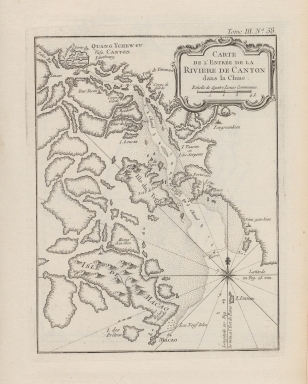
This is a map of the Pearl River with the route from Macau to Guanzhou (Canton). Xiangshan Island is marked as 'Isle de Macao' as was common on western maps of this period, demonstrating the importance of Macau over Xiangshan for foreign trade. On each side of Macau there are two anchors marking the location of the harbors and there are soundings up the Pearl River until Guangzhou. Westerners could not enter the city of Canton, but were confined to a small place in the western section in the western suburbs along the river. On the route there are marked many places that serve as navigational aid, there are Kau Chau Island (Neuf Isles), 'Sinn-gan hien' (Hong Kong), Humen (Bouche du Tigre), the already three famous Pagodas, the Chigang Pagoda (赤岗塔) or Red Stone Pagoda (Tour Tacon), the Pazhou Pagoda (琶洲塔) on the Island of Wampou and the Wenchang Pagoda (莲花塔) or Lotus Pagoda (Tour du Lion). Guangzhou is shown surrounded with forts and divided into 'Ville des Tartares' and 'V. de Chinois'.
|
|
Note:
|
Original is a copperplate printed map in the 'Le petit atlas maritime: recueil de cartes et plans des quatre parties du monde'.
|
|
Note:
|
There is a 16-point compass rose on the map with a fleur-de-lis indicating north. Rhumb lines for the principal winds are bold and half-winds are dotted.
|
|
Note:
|
Title inside scroll work cartouche.
|
|
Note:
|
Scale line underneath the title in black and white interchangeably.
|
|
Note:
|
Relief shown pictorially and bathymetric relief by soundings.
|
|
Note:
|
Map outlined in simple fillet.
|
|
Note:
|
Macao in China maps.
|
|
Note:
|
Macao and its surroundings.
|
|
Reference:
|
Phillips, P.L. A list of geographical atlases in the Library of Congress, vol. 3, n.º 3508, p. 348-355
|
|
Geographic Area:
|
Macao (China)
|
|
Geographic Area:
|
Pearl River Delta (China)
|
|
Relation Note:
|
Tome III, n.º 58
|
|
Pub Title:
|
Petit atlas maritime : recueil de cartes et plans des quatre parties du monde.
|
|
Pub Author:
|
Bellin, Jacques-Nicolas, 1703-1772
|
|
Pub Year:
|
1764
|
|
Pub location:
|
[Paris]
|
|
Provenance:
|
Harvard Map Collection
|
|
Provenance:
|
http://id.lib.harvard.edu/alma/990040126040203941/catalog
|
|
Provenance Call No.:
|
G1059 .B45 1764*
|
|
MUST holding:
|
https://must.primo.exlibrisgroup.com/permalink/853MUST_INST/reglfj/alma991002995349705076
|