Detail View: Old Maps Collection: 中華人民共和國掛圖
|
Barcode:
|
4687820500522
|
|
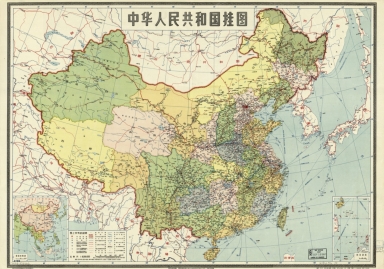
Title:
|
中華人民共和國掛圖
|
|
Original Title:
|
中華人民共和國掛圖
|
|
Contributor:
|
Di tu chu ban she
|
|
Category:
|
General Maps
|
|
Type:
|
Printed
|
|
Language:
|
Chinese
|
|
Create Year:
|
1950
|
|
Format:
|
JPEG2000, 9099 × 6385, 8.7MB
|
|
Scale:
|
Scale 1:8,000,000 (E 70⁰--E 145⁰/N 50⁰--N 20⁰)
|
|
Physical Map Dimension (cm):
|
51 × 72
|
|
Note:
|
Based on registered administrative map drawn prior to Sino-Japanese Conflict, 1937-1945, and revised according to new data. Includes insets showing adjacent countries and islands in South China Sea. "5101."
|
|
Note:
|
Macao and the surrounding islands were depicted in this map.
|
|
Note:
|
Macao in Routes
|
|
Geographic Area:
|
China
|
|
Pub Author:
|
Di tu chu ban she
|
|
Pub Year:
|
1950
|
|
Pub location:
|
[Shanghai]
|
|
Provenance:
|
Library of Congress Map Collections
|