Detail View: Old Maps Collection: Johnson's China and Japan
|
Barcode:
|
4687820500521
|
|
Title:
|
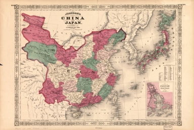
Johnson's China and Japan
|
|
Original Title:
|
Johnson's China and Japan
|
|
Contributor:
|
Johnson, A. J. (Alvin Jewett), 1827-1884
|
|
Category:
|
General Maps
|
|
Type:
|
Printed
|
|
Language:
|
English
|
|
Create Year:
|
1869
|
|
Format:
|
JPEG2000, 8009 × 5369, 8.9MB
|
|
Scale:
|
Scale [ca. 1:7,700,000]
|
|
Physical Map Dimension (cm):
|
38 × 54
|
|
Note:
|
From Johnson's Atlas of the world, 1869. ncludes index to Japanese provinces and inset of "Vicinity of Canton and Hong Kong ". At upper left: 106. At upper right: 107.
|
|
Note:
|
Macao and the surrounding islands were depicted in this map.
|
|
Geographic Area:
|
China
|
|
Geographic Area:
|
Japan
|
|
Pub Author:
|
Johnson, A. J. (Alvin Jewett), 1827-1884
|
|
Pub Year:
|
1869
|
|
Pub location:
|
New York
|
|
Provenance:
|
Library of Congress Map Collections
|