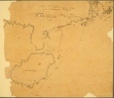
Detail View: Old Maps Collection: China: Swatow. Track chart, possibly based on Admiralty Chart 854, of the Naval Brigade and Boats commanded by Commodore Oliver J Jones against towns near Swatow, showing both shores of the Han river and the Chao Chao Foo creek.
|
Barcode:
|
4687820500517
|
|
Title:
|
China: Swatow. Track chart, possibly based on Admiralty Chart 854, of the Naval Brigade and Boats commanded by Commodore Oliver J Jones against towns near Swatow, showing both shores of the Han river and the Chao Chao Foo creek.
|
|
Original Title:
|
N/A
|
|
Category:
|
Thematic Maps
|
|
Type:
|
Manuscripts
|
|
Language:
|
English
|
|
Create Year:
|
1869
|
|
Format:
|
JPEG, 5496 × 4752, 7.1MB
|
|
Scale:
|
Scale not given
|
|
Physical Map Dimension (cm):
|
71.2 x 81
|
|
Note:
|
Scale: 1 inch to one third of a sea mile. Compass indicator. Signed by Edward C Sim, Capt RE, 1 February 1869. Originally accompanying Jones's report dated 30 January 1869.
|
|
Note:
|
Macao and the surrounding islands were depicted in this map.
|
|
Note:
|
局部圖
|
|
Note:
|
Macao and its Surroundings
|
|
Note:
|
Macao in Routes
|
|
Subject:
|
Voyages and travels
|
|
Geographic Area:
|
Macao (China)
|
|
Geographic Area:
|
Hainan Sheng (China)
|
|
Geographic Area:
|
Guangdong Sheng (China)
|
|
Pub Year:
|
1869
|
|
Provenance:
|
National Library of the Netherlands
|