Detail View: Old Maps Collection: Blaeu map of Southeast Asia and the surrounding areas
|
Barcode:
|
4687820500011
|
|
Title:
|
Blaeu map of Southeast Asia and the surrounding areas
|
|
Original Title:
|
India quae Orientalis dicitur et insulae adiacentes
|
|
Contributor:
|
Blaeu, Willem Janszoon, 1571-1638
|
|
Category:
|
Sea Charts
|
|
Type:
|
Printed
|
|
Language:
|
Latin
|
|
Create Year:
|
1635
|
|
Format:
|
JPEG, 8992 × 7632, 59.6MB
|
|
Scale:
|
ca. 1:17,700,000
|
|
Physical Map Dimension (cm):
|
42 × 54
|
|
Note:
|
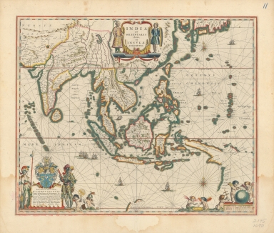
Blaeu was a representative of the golden age of Cartography in the Netherlands in 17th century and he had long served as the cartography officer in Dutch East India Company (VOC). He and his son Blaeu junior (Joan Blaeu, 1596 -1673) started to publish the Novus Atlas from 1634. The first year witnessed the publication of the German version, including a total of 208 maps. The Latin, Dutch and French version were published in the second year. After Blaeu senior died, his son continued to publish the atlas and expanded the space constantly. The maps were also increased approximately to 600. In 17th century Europe, Novus Atlas published by the Blaeu family contained most maps and was the most expensive atlas. In 1672, a big fire destroyed the drawing workshop of the Blaeu family; thereupon the vast publishing industry of Novus Atlas came to an end. This map is selected from the Novus Atlas published in 1635. It shows the vast area of the eastern Indian Ocean and the western Pacific Ocean, including the newly discovered western coastal areas of Australia by Dutch, but the mapmaker did not know the actual geography of Australia, so it was confused with New Guinea. The mapmaker mistakenly called the cape of Zhejiang and Ningbo area the “Ningbo’s corner” (C. d. Liampo) and falsely assumed that the coastline north of the cape in China was mainly straight, whereas the coastline of Guangdong and Fujian on the map is basically correct. Pearl River was known as “Guangdong River” (R. d. Canton), on the estuary of which an island was marked Macao, but the mapmaker wrongly placed Guangzhou (Canton) in the west region of the Pearl River. In the portraits below the map, besides a heavily armed Dutch there are several angels with different facial expressions, who are playing cross, globe, mariner’s compass, celestial globe or drums, lively and cute. Those lifelike images vividly capture the essence of modern Western culture: the Christian religion, science and technology, marine exploration and military conquest.
|
|
Note:
|
Macao in East Indies Maps
|
|
Subject:
|
Nautical charts
|
|
Geographic Area:
|
South Asia
|
|
Geographic Area:
|
Southeast Asia
|
|
Pub Title:
|
Dutch sea atlas.
|
|
Pub Author:
|
Wit, Frederik de
|
|
Pub Year:
|
1654
|
|
Pub location:
|
Amsterdam
|
|
Provenance:
|
Harvard Map Collection - Harvard College Library
|