Detail View: Old Maps Collection: 廣東省輿圖 = Map of Guangdong Province
|
Barcode:
|
4687820500515
|
|
Title:
|
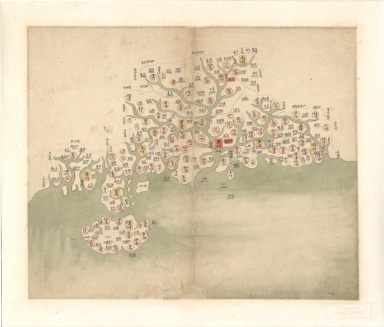
廣東省輿圖 = Map of Guangdong Province
|
|
Original Title:
|
N/A
|
|
Contributor:
|
Anonymous
|
|
Category:
|
General Maps
|
|
Type:
|
Manuscripts
|
|
Language:
|
Chinese
|
|
Create Year:
|
1754-1760
|
|
Format:
|
JPEG2000, 5296 × 4515, 4MB
|
|
Scale:
|
Scale not given
|
|
Physical Map Dimension (cm):
|
25 × 29
|
|
Note:
|
Shows administrative divisions of 18 provinces in Qing period. Pen-and-ink and watercolor.
|
|
Note:
|
Macao and the surrounding islands were depicted in this map.
|
|
Note:
|
Macao and its Surroundings
|
|
Subject:
|
Administrative and political divisions
|
|
Geographic Area:
|
Guangdong Sheng (China)
|
|
Geographic Area:
|
Hainan Sheng (China)
|
|
Geographic Area:
|
Macao (China)
|
|
Pub Title:
|
大清分省輿圖 = Provincial atlas of the great Qing Dynasty
|
|
Pub Author:
|
Anonymous
|
|
Pub Year:
|
1754-1760
|
|
Provenance:
|
Library of Congress Map Collections
|
|
MUST holding:
|
http://10.20.100.239/record=b1389995
|