Detail View: Old Maps Collection: 南北洋合圖 = Coastal map of Imperial Qing
|
Barcode:
|
4687820500512
|
|
Title:
|
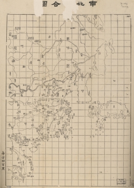
南北洋合圖 = Coastal map of Imperial Qing
|
|
Original Title:
|
南北洋合圖 = Coastal map of Imperial Qing
|
|
Contributor:
|
湖北省 (中國). 官書局
|
|
Category:
|
General Maps
|
|
Type:
|
Printed
|
|
Language:
|
Chinese
|
|
Create Year:
|
1870
|
|
Format:
|
JPEG2000, 5106 × 7122, 6.6MB
|
|
Scale:
|
Scale ca. 1:10,000,000
|
|
Physical Map Dimension (cm):
|
61 × 43
|
|
Note:
|
Covers East Asia coastal area from Kamchatka Peninsula to Indo-China Penisula. Wood block print. One grid equal 400 li.
|
|
Note:
|
Macao and the surrounding islands were depicted in this map.
|
|
Note:
|
Macao and its Surroundings
|
|
Note:
|
Macao in Asia Maps
|
|
Geographic Area:
|
East China Sea
|
|
Pub Title:
|
南北洋合圖 = Coastal map of Imperial Qing
|
|
Pub Author:
|
湖北省 (中國). 官書局
|
|
Pub Year:
|
1870
|
|
Pub location:
|
[Wuchang]
|
|
Provenance:
|
Library of Congress Map Collections
|