Detail View: Old Maps Collection: Mappemonde a l'usage du roy
|
Barcode:
|
4687820500509
|
|
Title:
|
Mappemonde a l'usage du roy
|
|
Contributor:
|
Delisle, Guillaume, 1675-1726, cartographer
|
|
Category:
|
Thematic Maps
|
|
Type:
|
Printed
|
|
Language:
|
French
|
|
Create Year:
|
1720
|
|
Format:
|
JPEG2000, 8264 × 5573, 7MB
|
|
Scale:
|
[ca. 1:76,000,000]. At equator (W 180⁰--E 180⁰/N 90⁰--S 90⁰)
|
|
Physical Map Dimension (cm):
|
47 x 71 cm, on sheet 56 x 79 cm
|
|
Note:
|
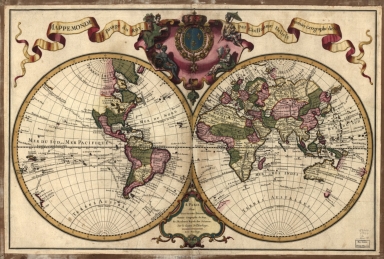
This double hemisphere map is by Guillaume Delisle a french cartographer known by its accuracy and personal integrity. His work was distinguished by its scientific basis and constant revision. Delisle marked a transition from the 'Dutch school', with maps highly decorative and artistically-orientated, to a more scientific approach. He reduced the decorative elements in maps, and emphasized the scientific aspect. His maps reflect the latest information available and did not contain fanciful detail in the absence of solid information. It can be said that he was the father of the modern cartography at commercial level. However this particular map does include the mythical lands of Juan De Gama's -a mythical land believed to have existed between Kamchatka and the American continent. On the map there are marked the routes of the principal circumnavigators: Magellan, Le Maire, St. Louis, Halley, Mendana, St. Antoine, Tasman, and Quiroz. The western portion of North America is still largely blank.
|
|
Note:
|
Title at the top inside banderole. Scrollwork cartouche in between the title with the coat of arms of the King of France surrounded by four representations of the continents: Europe as a woman with a cornucopia in her right hand; Africa represented by a native resting his right arm on a lion; America also represented by a native, an Indian with a parasol on his right hand a child on the left and Asia as an Arabic with an incense burner in his hands. A smaller scrollwork cartouche at the bottom center contains the imprint.
Equator line in black and white interchangeably.
|
|
Note:
|
Different administrative regions coloured in different colours.
|
|
Note:
|
Relief is shown pictorially.
|
|
Note:
|
Map outlined in double fillet.
|
|
Note:
|
Macao in World maps.
|
|
Reference:
|
Tooley's Dic. of Mapmakers, A-D [vol. 1], p. 353-355
|
|
Reference:
|
Shirley, R. The Mapping of the World: Early Printed World Maps 1472-1700, p. 597
|
|
Subject:
|
Navigation
|
|
Subject:
|
Nautical charts
|
|
Geographic Area:
|
World
|
|
Provenance:
|
Library of Congress
|
|
Provenance:
|
https://lccn.loc.gov/2005627023
|
|
Provenance Call No.:
|
G3200 1720 .L5 Vault
|
|
MUST holding:
|
https://must.primo.exlibrisgroup.com/permalink/853MUST_INST/reglfj/alma991002923849405076
|