Detail View: Old Maps Collection: 滇粤, 越南聯界與圖
|
Barcode:
|
4687820500508
|
|
Title:
|
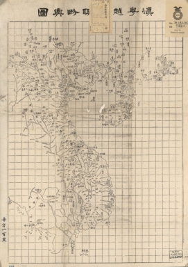
滇粤, 越南聯界與圖
|
|
Original Title:
|
滇粤, 越南聯界與圖
|
|
Contributor:
|
湖北省 (中國). 官書局
|
|
Category:
|
General Maps
|
|
Type:
|
Printed
|
|
Language:
|
Chinese
|
|
Create Year:
|
1870
|
|
Format:
|
JPEG2000, 5137 × 7267, 7MB
|
|
Scale:
|
ca. 1:4,000,000
|
|
Physical Map Dimension (cm):
|
55 × 41
|
|
Note:
|
Wood block print. Shows coastal area from Guangdong Province to Yunnan Province, including Indo-China Peninsula.
|
|
Note:
|
Macao and the surrounding islands were depicted in this map.
|
|
Note:
|
Macao and its Surroundings
|
|
Note:
|
Macao in Routes
|
|
Subject:
|
Boundaries
|
|
Geographic Area:
|
China
|
|
Geographic Area:
|
Vietnam
|
|
Geographic Area:
|
Yunnan Sheng (China)
|
|
Geographic Area:
|
Guangdong Sheng (China)
|
|
Pub Title:
|
滇粤, 越南聯界與圖
|
|
Pub Author:
|
湖北省 (中國). 官書局
|
|
Pub Year:
|
1870
|
|
Pub location:
|
[Wuchang]
|
|
Provenance:
|
Library of Congress Map Collections
|