Detail View: Old Maps Collection: Royaume du Japon
|
Barcode:
|
4687820500503
|
|
Title:
|
Royaume du Japon
|
|
Original Title:
|
Royaume du Iapon
|
|
Contributor:
|
Briet, Philippe, 1601-1668, cartographer
|
|
Contributor:
|
Somer, Jean, fl. 1650-ca. 1663, engraver
|
|
Contributor:
|
Mariette, Pierre-Jean, 1694-1774, printer.
|
|
Category:
|
General Maps
|
|
Type:
|
Printed
|
|
Language:
|
French
|
|
Create Year:
|
[1650]
|
|
Format:
|
JPEG 14449 × 10417, 42.6MB
|
|
Scale:
|
[ca. 1:3,200,000] (E 127°34'00"-E 153°03'00"/N 41°59'00"-N 28°46'00").
|
|
Physical Map Dimension (cm):
|
37 x 52 cm, on sheet 47 x 63 cm
|
|
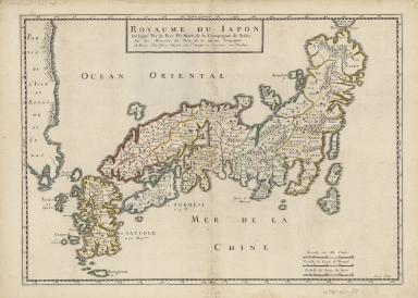
Note:
|
This is an important 17th century map of Japan by Philip Briet, a Jesuit since 1619 and also a teacher of humanities and rhetoric. He wrote literature, as well as history and historical geography. The map is based on the map of the Jesuit missions published in 1646 by Father Antonio Francisco Cardim (1596-1659). It itself was derived from one of the last maps sent from Japan, that of Father Girolamo de Angelis (ca. 1567-1623), sent to Europe in 1621. It depicts a fairly well-shaped Japan with 66 regional divisions clearly drawn as the major cities in the area. Kyushu (Ximo) and Shikoku (Xicocu) are shown with exaggerated inlets, and present-day island of Hokkaido in the north is name 'Terre de Iesso' for little was known about it at that time. Korea (Coray) is described as an island, but barely visible on the map.
|
|
Note:
|
Original is a printed map watercolor by hand, 36 x 57 cm.
|
|
Note:
|
On the right bottom corner of the map: "Somer sculp."
|
|
Note:
|
Title inside triple fillet cartouche on the top of the map.
|
|
Note:
|
Triple scale line in Italian miles, Portuguese and Japanese leagues in black and white interchangeably on the right bottom corner of the map.
|
|
Note:
|
Relief shown pictorially.
|
|
Note:
|
Different administrative regions outlined in different colors.
|
|
Note:
|
The four borders of the map with latitude and longitude lines and labelled with North, South, East and West in Italian Septentrionis, Midi, Orient and Occident.
|
|
Note:
|
Map outlined in simple fillet.
|
|
Geographic Area:
|
Japan
|
|
Geographic Area:
|
Korea
|
|
Provenance:
|
Harvard Map Collection
|
|
Provenance:
|
http://id.lib.harvard.edu/alma/990125724780203941/catalog
|
|
Provenance Call No.:
|
G7960 1650 .B7
|
|
MUST holding:
|
https://must.primo.exlibrisgroup.com/permalink/853MUST_INST/171sgkf/alma991002990749105076
|