Detail View: Old Maps Collection: Chinesisches Reich
|
Barcode:
|
4687820500502
|
|
Title:
|
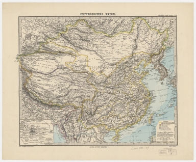
Chinesisches Reich
|
|
Original Title:
|
Chinesisches Reich
|
|
Contributor:
|
Berghaus, Hermann, 1828-1890
|
|
Category:
|
General Maps
|
|
Type:
|
Printed
|
|
Language:
|
German
|
|
Create Year:
|
1880
|
|
Format:
|
JPEG, 11802 × 9792, 42.9MB
|
|
Scale:
|
approximately 1:12,500,000
|
|
Physical Map Dimension (cm):
|
32 × 41.6
|
|
Note:
|
Includes inset: "Pe-King, King-Ischeng od. King-Tu (1:500,000)." Shows also Russian, British and Portuguese possessions.
|
|
Note:
|
Macao and the surrounding islands were depicted in this map.
|
|
Note:
|
Macao in China Maps
|
|
Geographic Area:
|
China
|
|
Relation Note:
|
In : Stieler, Adolf, 1775-1836. Stieler’s Hand-Atlas. Gotha : Justus Perthes, [1880?] No. 66
|
|
Pub Title:
|
Stieler's Hand-Atlas
|
|
Pub Author:
|
Stieler, Adolf, 1775-1836
|
|
Pub Year:
|
1880
|
|
Pub location:
|
Gotha
|
|
Provenance:
|
Harvard Map Collection - Harvard College Library
|