Detail View: Old Maps Collection: Asia, drawn from the best authorities : for the elucidation of Lavoisne's genealogical, historical, chronological, & geographical atlas
|
Barcode:
|
4687820500500
|
|
Title:
|
Asia, drawn from the best authorities : for the elucidation of Lavoisne's genealogical, historical, chronological, & geographical atlas
|
|
Original Title:
|
Asia, drawn from the best authorities : for the elucidation of Lavoisne's genealogical, historical, chronological, & geographical atlas
|
|
Contributor:
|
Aspin, Jehoshaphat, active 18th century-19th century
|
|
Category:
|
General Maps
|
|
Type:
|
Printed
|
|
Language:
|
English
|
|
Create Year:
|
1813
|
|
Format:
|
JPEG, 12986 × 10490, 44.7MB
|
|
Scale:
|
ca. 1:26,000,000 (E 10⁰--E 180⁰/N 80⁰--S 14⁰)
|
|
Physical Map Dimension (cm):
|
31 × 32
|
|
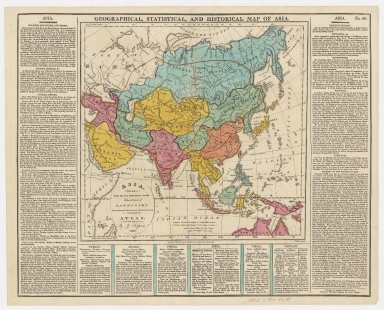
Note:
|
Wood engraving, hand-colored. Title above the map: Geographical, statistical, and historical map of Asia. Prime meridian: London. Sheet "printed by J. Barfield, Wardour-Street, printer to His Royal Highness the Prince Regent." Sheet numbered 60, includes text describing Asia, Turkey, Arabia, Persia, India, China, and Tartary. Sea of Korea referred to as "Corean Sea."
|
|
Geographic Area:
|
Asia
|
|
Geographic Area:
|
China
|
|
Geographic Area:
|
Russia
|
|
Geographic Area:
|
Japan
|
|
Geographic Area:
|
Korea
|
|
Geographic Area:
|
India
|
|
Geographic Area:
|
Philippines
|
|
Geographic Area:
|
Malay Archipelago
|
|
Pub Year:
|
1813
|
|
Pub location:
|
London
|
|
Provenance:
|
Harvard Map Collection - Harvard College Library
|