Detail View: Old Maps Collection: Carte particulière de l'entrée de Canton
|
Barcode:
|
4687820500490
|
|
Title:
|
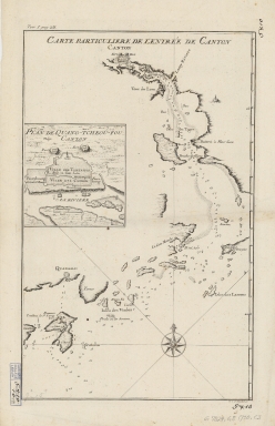
Carte particulière de l'entrée de Canton
|
|
Original Title:
|
Carte particulière de l'entrée de Canton
|
|
Contributor:
|
Anonymous
|
|
Category:
|
Sea Charts
|
|
Type:
|
Printed
|
|
Language:
|
French
|
|
Create Year:
|
1730-1770
|
|
Format:
|
JPEG, 7506 × 11260, 77.5MB
|
|
Scale:
|
approximately 1:515,000
|
|
Physical Map Dimension (cm):
|
39 × 24
|
|
Note:
|
Includes inset: Plan de Quang-Tcheou-Fou vulgo Canton. "Tom. 1, pag. 231."
|
|
Note:
|
Macao and the surrounding islands were depicted in this map.
|
|
Note:
|
局部圖
|
|
Note:
|
Macao and its Surroundings
|
|
Note:
|
Macao in Routes
|
|
Subject:
|
Harbors
|
|
Subject:
|
Nautical charts
|
|
Geographic Area:
|
Macao (China)
|
|
Geographic Area:
|
Guangzhou Shi (China)
|
|
Pub Year:
|
1730-1770
|
|
Pub location:
|
[Netherlands]
|
|
Provenance:
|
Harvard Map Collection - Harvard College Library
|
|
MUST holding:
|
http://10.20.100.239/record=b1352184
|