Detail View: Old Maps Collection: Mar di India
|
Barcode:
|
4687820500489
|
|
Title:
|
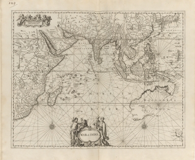
Mar di India
|
|
Original Title:
|
Mar di India
|
|
Contributor:
|
Anonymous
|
|
Category:
|
Sea Charts
|
|
Type:
|
Printed
|
|
Language:
|
Latin
|
|
Create Year:
|
169-
|
|
Format:
|
JPEG, 9620 × 7891, 77.6MB
|
|
Scale:
|
Scale not given
|
|
Note:
|
A reissue of 163 maps published by N. Visscher, F. de Wit, J. Blaeu and others, dated 1659-1688. In the issue described by Phillips, the index calls for 107 maps; in this issue, it calls for 163.
|
|
Note:
|
Macao was marked on coast of Pearl River Estuary in this map.
|
|
Note:
|
Macao and its Surroundings
|
|
Note:
|
Macao in Asia Maps; Macao in East Indies Maps
|
|
Reference:
|
Phillips, P.L. Atlases, p. 245
|
|
Subject:
|
Nautical charts
|
|
Geographic Area:
|
Indian Ocean
|
|
Geographic Area:
|
China
|
|
Geographic Area:
|
Japan
|
|
Geographic Area:
|
Korea
|
|
Pub Title:
|
Atlas minor : novissimas & maximè necessarias orbis terrarum tabulas geographicas complectens.
|
|
Pub Author:
|
Visscher, Nicolaes, 1649-1702
|
|
Pub Author:
|
Wit, Frederik de
|
|
Pub Author:
|
Blaeu, Joan, 1596-1673
|
|
Pub Year:
|
169-
|
|
Pub location:
|
Amsterdam
|
|
Provenance:
|
Houghton Library - Harvard College Library
|