Detail View: Old Maps Collection: 大清萬年一統地理全圖 = Complete geographical map of the great Qing Dynasty
|
Barcode:
|
4687820500482
|
|
Title:
|
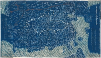
大清萬年一統地理全圖 = Complete geographical map of the great Qing Dynasty
|
|
Original Title:
|
大清萬年一統地理全圖 = Complete geographical map of the great Qing Dynasty
|
|
Contributor:
|
黃千人, active 18th century
|
|
Category:
|
General Maps
|
|
Type:
|
Printed
|
|
Language:
|
Chinese
|
|
Create Year:
|
1814
|
|
Format:
|
JPEG, 27393 × 15785, 87.6MB
|
|
Scale:
|
[ca. 1:2,500,000]
|
|
Physical Map Dimension (cm):
|
132 × 227
|
|
Note:
|
Covers the area from Korea to Pamirs, and from Heilongjiang river to the islands of the South China Sea. Shows the mountains, rivers, coasts, territory and administrative divisions of the Qing Empire. Also shows a distorted view of surrounding countries. Translated title: Universal map of the Qing Empire. Wood block print. Revised edition of the map originally drawn by Huang Qianren in 1767. Includes text.
|
|
Geographic Area:
|
China
|
|
Pub Title:
|
大清萬年一統地理全圖 = Complete geographical map of the great Qing Dynasty
|
|
Pub Author:
|
黃千人, active 18th century
|
|
Pub Year:
|
[1814-1816]
|
|
Pub location:
|
[China]
|
|
Provenance:
|
Harvard-Yenching Library
|
|
MUST holding:
|
http://10.20.100.239/record=b1390040
|