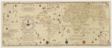
Detail View: Old Maps Collection: Carta Universal en que se contiene todo lo que del mundo se ha descubierto fasta agora / hizola Diego Ribero cosmographo de Su magestad, Anõ de 1529. e[n] Sevilla. La qual se devide en dos partes conforme ala capitulaçion que hizieron los catholicos Reyes de españa [y] el Rey don Juan de portogual en Tordesillas, Anõ de 1494.
|
Barcode:
|
4687820500481
|
|
Title:
|
Carta Universal en que se contiene todo lo que del mundo se ha descubierto fasta agora / hizola Diego Ribero cosmographo de Su magestad, Anõ de 1529. e[n] Sevilla. La qual se devide en dos partes conforme ala capitulaçion que hizieron los catholicos Reyes de españa [y] el Rey don Juan de portogual en Tordesillas, Anõ de 1494.
|
|
Other Title:
|
Propaganda Chart
|
|
Contributor:
|
Ribeiro, Diogo, fl. 1519-1533, cartographer
|
|
Contributor:
|
Griggs, William, 1832-1911
|
|
Category:
|
Sea Charts
|
|
Type:
|
Manuscripts
|
|
Language:
|
Spanish
|
|
Language:
|
Latin
|
|
Create Year:
|
1529
|
|
Format:
|
JPEG2000, 34701 × 14972, 77.9MB
|
|
Scale:
|
Scale not given.
|
|
Physical Map Dimension (cm):
|
79 x 188 cm
|
|
Note:
|
Diogo Ribeiro was a Portuguese cartographer in service of King Carlos V of Spain, he succeeded Sebastian Cabot as pilot major. By royal decree in 10th July of 1523 Ribeiro was nominated cosmographer of the king and maker of charts and globes, astrolabes, compasses, quadrants and ballastellas. Actually the four complete planispheres by Diogo Ribeiro contain the earliest known representations of navigational instruments on maps. Few chart-makers have depicted navigational aids in the main body of a map, and no other charts are known on which a variety of instruments are portrayed together with lengthy inscriptions describing their use. This illustrations are not merely decorative but should be interpreted as statements selected to further Ribeiro's ambitions as a cosmographer. By depicting these particular instruments Ribeiro was demonstrating his support for celestial navigation over more traditional forms of navigation. The chart was commissioned by Agostini Chigi an immensely rich banker that built the palace and gardens afterwards known as the Farnesina, decorated by Raphael. He was the most famous member of the family during the Renaissance and became finance minister to Pope Julius II, who gave him the privilege of quartering his own arms with those of the Chigi family. It is the first planisphere based on empirical latitude observations and the first to depict the real extension of the Pacific Ocean, strongly influenced by the information obtained during the Magellan-Elcano trip around the world. The detailed and continuous coast of North America denotes the 1524-1525 expedition of Esteban Gómez. The chart is the latest update of 'Padrón Real', the official and secret Spanish master map, kept in 'Casa de Contratación' in Seville, used as a template for the maps present on all Spanish ships during the 16th century. Therefore it had a more precise and updated delimitation of the known world, particularly America. However Australia and Antarctica are not yet present and the Indian continent is far too small. It is also the first European cartographic representation to show Canton -marked 'Cantam'-, the surroundings and the 'Pescadores Islands'.
|
|
Note:
|
Original is a manuscript map in four parchment sheets mounted, 85 x 205 cm. One of the earliest names for this map was Propaganda Chart.
|
|
Note:
|
The chart is heavily ornamented with scientific instruments and legends with navigation rules. On the right bottom corner of the map there is a horary quadrant described on the legend in a cartouche left to the drawing. There is also a declination table incorporating a calendar and the only one by Ribeiro that has a compass rose in the middle and drawings of representations of the zodiac signs on the outside. The declination compass has 23,5 cm in diameter and two cartouches -one above other below. The top one has details for calculation of the sun's position and declination on any day of the year and gives the dates of the solstices and equinoxes. The cartouche on the bottom describes how solar declination should be used in conjunction with readings from the quadrant or astrolabe to determine latitude, and how to convert between degrees and leagues. On the right bottom corner of the map is the mariner's astrolabe -12 cm in diameter- as identified by the legend below. The astrolabe is strategically placed south to the important Maluku Islands and on it fly flags from poles of unequal length placed at unequal distances from its top. The shorter pole bears the Portuguese standard positioned at only 165 degrees east on the unmarked line of longitude, the Spanish standard, on a pole more than twice as long, positioned 180 degrees east of the Tordesillas line. This representation favors the Spaniards on ownership of the Maluku Islands disputed between Portugal and Spain in 1495-1529.
|
|
Note:
|
There are three coat of arms on the bottom of the map. The one on the right is of the Chigi family, the center one is of Pope Julius II and the one on the left is of Augustini Chigi after combining the arms of his family with the ones of Pope Julius II.
|
|
Note:
|
There are 20 vessels in the map with legends bellow but three in the Atlantic Ocean. All the legends mention the Maluku Islands, there is a vessel with 'bueluo a maluco', eight with 'vengo de maluco' and another eight with 'voy a maluco'. Some also have a more developed legend with historic elements of travels.
|
|
Note:
|
There are a large number of buildings scattered all over the map depicting mostly cities. It can also be seen the Tower of Babel and Jerusalem depicted as a calvary.
|
|
Note:
|
There are 19 wind roses on the map with three of them being only half compass rose. The only big one is in the middle of the declination compass and has a fleur de lis indicating north; it is colored blue, green, red, yellow and gold. All the smaller ones have an arrow indicating north and are colored blue, red, green and yellow. The rhumb lines are all black except for the green half winds.
|
|
Note:
|
The sea names, the oceans, the tropics and the Equator are written in banderoles; being 'Occeanus Occidentalis' the only exception. Place names written in black and red. Both tropic lines, the Equator and 'Circulus Arcticus' and 'Circulus A[n]tarcticus' in red.
|
|
Note:
|
The Papal Meridian from Tordesillas Treaty is in red with the Spanish and Portuguese flag on each side of it accordingly.
|
|
Note:
|
There are three vertical scale lines on the map, all inside banderoles. One is on the top left corner of the map, other in between Brazil and Africa and the last one on the bottom right corner of the map next to the astrolabe.
|
|
Note:
|
On the four corners of the map there are windheads.
|
|
Note:
|
Land masses outlined in green.
|
|
Note:
|
Relief shown pictorially, with depictions of various types of flora. There are also present the mythical Mountains of the Moon -a legendary mountain or mountain range in east Africa at the source of the Nile River- and the 'Hyperborei Montes' -the mythical name of an imaginary range of mountains in the north of the earth, also named Rhipaei Montes. On the chart are also visible a vast range of animals especially in South America, Africa and Asia.
|
|
Note:
|
Early old map depicting the world.
|
|
Reference:
|
Cortesão, A. Portugalliae Monumenta Cartographica, vol. I, p. 101-106
|
|
Reference:
|
Cortesão, A. Cartografia e Cartógrafos Portugueses dos séculos XV e XVI, vol. II, p. 145-151
|
|
Reference:
|
Davies, S. The Navigational Iconography of Diogo Ribeiro’s 1529 Vatican Planisphere, Imago Mundi, vol. 55, p. 103-112
|
|
Reference:
|
Fernández Duro, C. Las cartas universales de Diego Ribero (siglo XVI), Boletín de la Real Academia de la Historia, vol. 2, 1888, p. 319-325
|
|
Reference:
|
Castillo Oreja, M.A. América en la Cartografia del Siglo XV (1500-1556) (II), Quiroga, nº 14, p. [56]-71
Pásztor, L. Biblioteca Apostolica Vaticana, Guida delle fonti per la storia dell'America Latina negli archivi della Santa Sede e negli archivi ecclesiastici d'Italia, Collectanea Archivi Vaticani 2, 601
|
|
Reference:
|
Tooley's Dict. of mapmakers, vol. [4] Q-Z, p. 39
|
|
Subject:
|
Nautical charts
|
|
Subject:
|
Discoveries in geography
|
|
Subject:
|
Discovery and exploration
|
|
Subject:
|
World -- Maps
|
|
Geographic Area:
|
World
|
|
Pub Title:
|
Carta Universal en que se contiene todo lo que del mundo se ha descubierto fasta agora, hizola Diego Ribero cosmographo de Su Magestad: Anõ de 1529
|
|
Pub Author:
|
Ribeiro, Diogo, fl. 1519-1533
|
|
Pub Author:
|
Griggs, William, 1832-1911
|
|
Pub Year:
|
[1893]
|
|
Pub location:
|
London
|
|
Provenance:
|
Harvard College Library
|
|
Provenance:
|
http://id.lib.harvard.edu/alma/990115269250203941/catalog
|
|
Provenance Call No.:
|
MAP-LC G3200 1529 .R5 1893
|