Detail View: Old Maps Collection: Novissima totius terrarum orbis tabula
|
Barcode:
|
4687820500020
|
|
Title:
|
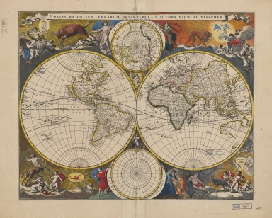
Novissima totius terrarum orbis tabula
|
|
Contributor:
|
Visscher, Nicolaes, 1649-1702, author, printer
|
|
Category:
|
Hemispheres
|
|
Type:
|
Printed
|
|
Language:
|
Latin
|
|
Create Year:
|
[ca. 1690]
|
|
Format:
|
JPEG 15568 × 12570, 68.8MB
|
|
Page No.:
|
1
|
|
Scale:
|
[ca. 1:50,000,000].
|
|
Physical Map Dimension (cm):
|
44 x 55 cm, on sheet 70 x 97 cm
|
|
Note:
|
This is a double hemisphere map with two ancillary polar projections to the top and bottom of the main map. It seems the map is almost identical to an early edition from 1658 by Claes Jansz Visscher -father to Nicolaes Visscher- and so it features an insular California, partial coastlines for northwestern America, eastern New Zealand, and western Australia -here named 'Hollandia Nova'-, a truncated China and Tartary, an east-west oriented Japan, and no landmass at the southern pole. The major change is the Anian island in the 'Polus Arcticus' map, center top, that is now smaller in about 10 degrees. As many of the later 17th century Dutch world maps the attractiveness is in the bordure decorations.
|
|
Note:
|
Map 1: Hemisphere with North and South America. - 27 cm in diam. -- Map 2: Hemisphere with Europe, Africa, Asia and Australia. - 27 cm in diam. -- Map 3: 'Polus Arcticus'. - 12 cm in diam. -- Map 4: 'Polus Antarcticus'. - 12 cm in diam.
|
|
Note:
|
Original is a hand colored map with 2 hemispheres, 26 cm in diam. each, measuring 43 x 53 cm. This map is pl. no. [1] from 'Atlas minor sive Geographia compendiosa qua orbis terrarum per paucas attamen novissimas tabulas ostenditur' by Nicolaes Visscher.
|
|
Note:
|
Title of the map is on a banderole on the top of the map. Surrounding the globes are colored illustrations of the figures and animals of the Zodiac accompanied by cherubs. Aries represented by a ram mounted by a cherub, Gemini represented by two identical cherubs, Taurus as a bull and Leo as a lion, Virgo represented as a blue winged angel, Cancer as a crab held by a cherub, Sagittarius with a bow and arrow, Libra as scales held by a cherub, Scorpio as a scorpion on a yellow hallow, Aquarius represented as an old man leaning on a amphora with running water, Capricorn represented by a goat held by two cherubs and Pisces as two fishes on a plate held by three cherubs. Each of the ancillary maps are sided by the personified seasons. On the left side of the Arctic sphere is a winged personification of Spring with a trumpet in her left hand; on the right side is Summer, in a loose-fitting dress. As for the Antarctic sphere in the bottom left, Autumn is holding a bunch of grapes accompanied by a dog and on the opposite side is Winter as an old stooped figure who guards his fire.
|
|
Note:
|
Relief shown pictorially.
|
|
Note:
|
Continents outlined in color.
|
|
Note:
|
Map outlined in double fillet.
|
|
Note:
|
Macao in world maps.
|
|
Reference:
|
Phillips, P.L. A list of geographical atlases in the Library of Congress, with bibliographical notes, vol. 1, 507
|
|
Reference:
|
Shirley, R.W. Mapping of the world, 486
|
|
Reference:
|
Koeman, C. Atlantes Neerlandici, vol. 4, 13
|
|
Geographic Area:
|
World
|
|
Relation Note:
|
Pl. 1
|
|
Pub Title:
|
Atlas minor sive Geographia compendiosa qua orbis terrraum per paucas attamen novissimas tabulas ostenditur.
|
|
Pub Author:
|
Visscher, Nicolaes, 1649-1702, author, printer
|
|
Pub Year:
|
[ca. 1690]
|
|
Pub location:
|
Amstelaedami
|
|
Provenance:
|
Harvard College Library
|
|
Provenance:
|
http://id.lib.harvard.edu/alma/990127201160203941/catalog
|
|
Provenance Call No.:
|
G3200 1690 .V5
|
|
MUST holding:
|
https://must.primo.exlibrisgroup.com/permalink/853MUST_INST/171sgkf/alma991000042919705076
|