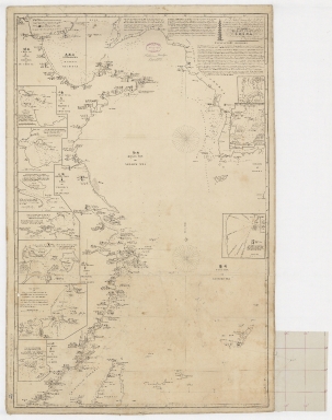
Detail View: Old Maps Collection: To John Reeves Esq.re F.R.S. for the liberal aid of his Chinese m.s.s. and the benefit derived from his excellent map of that Empire presented by him to the Hon.ble East India Company this Chart of the East Coast of China
|
Barcode:
|
4687820500450
|
|
Title:
|
To John Reeves Esq.re F.R.S. for the liberal aid of his Chinese m.s.s. and the benefit derived from his excellent map of that Empire presented by him to the Hon.ble East India Company this Chart of the East Coast of China
|
|
Other Title:
|
Chart of the East Coast of China
|
|
Other Title:
|
Plan of Che-Fow-Taou Harbour.
|
|
Other Title:
|
Survey of Napakiang Roads.
|
|
Other Title:
|
Plan of Wei-Hae-Wei-Harbour.
|
|
Other Title:
|
Plan of Killon Harbour.
|
|
Other Title:
|
Plan of the entrance to the river Woo-Sung leading to Shang-Hae-Heen.
|
|
Other Title:
|
Plan of the entrance of the river Min and Ting-Hae bay.
|
|
Other Title:
|
Plan of Hea Mun 廈門 or Amoy Harbour.
|
|
Other Title:
|
肺頭 Hoo-e-Tow Bay.
|
|
Other Title:
|
Eye sketch or Plan of Tung-Shan-Ying Bay, and Hoo-Tow-Shan or Dansborg's Bay.
|
|
Other Title:
|
Plan of Nan-Gaou 南澳 or South Harbour called also Namo.
|
|
Contributor:
|
Horsburgh, James, 1762-1836, author, publisher
|
|
Contributor:
|
J. & C. Walker (Firm), engraver
|
|
Contributor:
|
Ross, Daniel, 1780-1849, cartographer
|
|
Contributor:
|
Hall, Basil, 1788-1844, cartographer
|
|
Contributor:
|
Crawford, James H., fl. 18--, cartographer
|
|
Contributor:
|
Rancliffe, George Augustus Henry Anne Parkyns, Baron, 1785-1850, cartographer
|
|
Contributor:
|
Rees, Thomas, 1790-1870, cartographer
|
|
Contributor:
|
Dayot, Félix, 1772-1821, cartographer
|
|
Contributor:
|
Sturgis, Josiah, 1773-1850, cartographer
|
|
Contributor:
|
Rees, John, 1752-18--, cartographer
|
|
Contributor:
|
Hoskiaer, Jacob, 1808-1836, cartographer
|
|
Contributor:
|
Dalrymple, Alexander, 1737-1808, bibliographic antecedent
|
|
Contributor:
|
Reeves, John, 1774-1856, dedicatee
|
|
Category:
|
Sea Charts
|
|
Type:
|
Printed
|
|
Language:
|
English
|
|
Language:
|
Traditional Chinese
|
|
Create Year:
|
1835
|
|
Format:
|
JPEG, 19840 × 25073, 87.1MB
|
|
Scale:
|
Scale [ca.1:1,900,000] (E 114°56ʹ00ʺ--E 129°03ʹ00ʺ/N 40°32ʹ00ʺ--N 23°14ʹ00ʺ)
|
|
Physical Map Dimension (cm):
|
93 x 62 cm, on sheet 126 x 80 cm
|
|
Note:
|
This map was made by Scottish hydrographer James Horsburgh who worked for the British East India Company (EIC) and charted much of China, Southeast Asia, India and contiguous regions in the late 18th and early 19th centuries. However, as easily perceived by the insets, it is also a compilation of knowledge collected by many other authors. Horsburgh went to sea at the age of 16 and in 1786 sailed from Batavia to Ceylon and was subsequently shipwrecked on the island of Diego Garcia. This influenced him to produce accurate maps. EIC hydrographer Alexander Dalrymple published three of Horsburgh’s earliest charts and observations on the Eastern Seas on behalf of the EIC. Upon Horsburgh's retirement, due to his high society contacts, he assured nomination and approval as a Fellow of the Royal Society and continued to publish on nautical navigation. After his death and with the demise of the EIC, his charts passed to the Admiralty Hydrographic Office, who reissued them. This particular chart is very detailed for not only navigational aid information is given on the extensive text legends at the top of the chart, but also Chinese language and costumes information. For some of the places it is given the English name but also the traditional Chinese. The chart shows the east coast of China, the Yellow Sea and extends to the west coast of Korea; northern Taiwan is also included. Detailed soundings are given for great part o the chart and all the insets.
|
|
Note:
|
Inset 1: Plan of Che-Fow-Taou Harbour / by Capt.n Ross the Company's marine surveyor in 1816 reduced to the original scale. - Scale indeterminable. - 10 x 12 cm. -- Inset 2: Survey of Napakiang Roads / by Cap.t Basil Hall R.N. in 1813. - Scale indeterminable. - 7 x 7 cm. -- Inset 3: Plan of Wei-Hae-Wei-Harbour / By Capt.n J. Crawford of the Indian Navy in 1816 reduced to half the original scale. - Scale indeterminable. - 11 x 12 cm. -- Inset 4: Plan of Killon Harbour / by Lieu.t G. Parkyns. - Scale indeterminable. - 12 x 9 cm. -- Inset 5: Plan of the entrance to the river Woo-Sung leading to Shang-Hae-Heen / reduced from the survey of Capt.n Thomas Rees in 1832. - Scale indeterminable. - 10 x 14 cm. -- Inset 6: Plan of the entrance of the river Min and Ting-Hae bay / Chiefly from the explorations of Cap.n Thomas Rees in 1832. - Scale indeterminable. - 7 x 16 cm. -- Inset 7: Plan of Hea Mun 廈門 or Amoy Harbour / Chiefly taken from M.r Dalrymples work and Captain F. Dayots M.S. of 1805. -- Inset 8: 肺頭 Hoo-e-Tow Bay / This sketch of the above named Bay is given by Captain Sturgis of the Greyhound Schooner, where she anchored, May 23.rd 1827. - Scale indeterminable. - 11 x 11 cm. -- Inset 9: Eye sketch or Plan of Tung-Shan-Ying Bay, and Hoo-Tow-Shan or Dansborg's Bay / by Capt.n John Rees and Jacob Hoskiaer 1832. - Scale indeterminable. - 14 x 17 cm. -- Inset 10: Plan of Nan-Gaou 南澳 or South Harbour called also Namo / By Capt.n D.l Ross. - Scale indeterminable. - 10 x 8 cm.
|
|
Note:
|
Original is a printed map, 98 x 63 cm.
|
|
Note:
|
On the right bottom corner of the map: "Engraved by J. & C. Walker".
|
|
Note:
|
Left to the title there is an illustration of a Pagoda.
|
|
Note:
|
Map with two 32-point compass roses with a fleur de lis indicating north.
|
|
Note:
|
And all insets with a 4-point compass rose with an arrow indicating north.
|
|
Note:
|
All insets with sale line in nautic miles with the exception of inset 8, which is given in miles.
|
|
Note:
|
Relief shown by hachures and bathymetric relief by soundings.
|
|
Note:
|
Map with graticule.
|
|
Note:
|
The four borders if the map with latitude and longitude lines.
|
|
Note:
|
Map outlined in triple fillet with insets outlined in simple bold fillet.
|
|
Subject:
|
Coasts
|
|
Subject:
|
Nautical charts
|
|
Geographic Area:
|
China
|
|
Geographic Area:
|
Korea
|
|
Geographic Area:
|
Taiwan
|
|
Geographic Area:
|
Yellow Sea
|
|
Geographic Area:
|
East China Sea
|
|
Provenance:
|
Harvard College Library
|
|
Provenance:
|
http://id.lib.harvard.edu/alma/990138096810203941/catalog
|
|
Provenance Call No.:
|
G7821.P5 1835 .H6
|
|
MUST holding:
|
https://must-primo.exlibris.com.cn/permalink/853MUST_INST/171sgkf/alma991000150299705076
|