Detail View: Old Maps Collection: Ebstorf mappamundi
|
Barcode:
|
3687800285630D
|
|
Title:
|
Ebstorf mappamundi
|
|
Original Title:
|
Monialium Ebstorfensium Mappamundi quae exeunte saeculo XIII. videtur picta, Hannoverae nunc adservatur
|
|
Other Title:
|
Mappamundi quae exeunte saeculo XIII. videtur picta, Hannoverae nunc adservatur
|
|
Contributor:
|
Gervase, of Tilbury, ca. 1160-ca. 1211, cartographer
|
|
Contributor:
|
Miller, Konrad, 1844-1933, editor
|
|
Contributor:
|
Eckstein & Stähle, publisher
|
|
Category:
|
Early Old Maps
|
|
Type:
|
Printed
|
|
Language:
|
Latin
|
|
Create Year:
|
[ca. 1280]
|
|
Create Year:
|
1898
|
|
Format:
|
JPEG 17003 × 19051, 85.3MB
|
|
Scale:
|
Scale not given.
|
|
Physical Map Dimension (cm):
|
102 x 100 cm
|
|
Note:
|
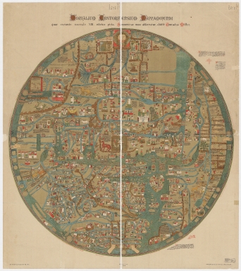
he Ebstorf World Map Ebstorf is the largest circular mappa mundi from the Middle Ages. It counts among the most valuable treasures of Ebstorf cloister and all of the other cloisters and it is the most famous, comprehensive and by far the largest illustrated medieval map of the world. It is a medieval map of the known world of a form deriving from the T and O pattern, dating from c. 1280. The map was found in a dank, windowless utility room in 1830 by Charlotte von Lassberg, a conventual of Ebstorf cloister. The original was destroyed in 1943, during the Allied bombing of Hanover in World War II. There survives a set of black-and-white photographs of the original map, taken in 1891, and several color facsimiles of it were made before it was destroyed. In the Ebstorf Map there are 500 buildings, 160 rivers, lakes, seas and other waterways, 60 islands or mountains, 45 people or mythical persons, and 60 animals, which is makes it one with the most entries. Around the map there is text including descriptions of animals, the creation of the world, definitions of terms, and a sketch of the more common sort of T and O map with an explanation of how the world is divided into three parts. In the middle of the map we see Jerusalem, the spiritual center of Christendom, located at Christ's navel. Europe is in the bottom left quadrant of the map, Africa in the bottom right, and Asia dominates the upper half. In Asia depictions of cities alternate with Biblical motifs, real people and mythical peoples. Africa appears as a largely unknown continent: whereas Cairo, Alexandria and ancient cities like Carthage and the sources of the Nile are shown. Pictures of animals and fabulous peoples dominate the area. Apart from the Bible, Asia and Africa also reflect Greek and Roman ancient history. Trade centers and further cities situated on trade routes such as the Silk Road are also present on the map. Europe is shown from the Urals to the Strait of Gibraltar, from the Northern Ocean to Sicily. It is also included mountains and mountain ranges, rivers and islands of the Mediterranean.
|
|
Note:
|
This is a facsimile with a background clean up of the original manuscript map on vellum, 306 x 306 cm.
|
|
Note:
|
The head of Christ is depicted at the top of the map, the direction of Paradise, with Adam and Eve, showing the Fall of Man tempted by the serpent. His hands mark the northern and southern limits of the known world, and his feet are at Gibraltar where the Mediterranean meets the Atlantic, at the bottom of the map. Near Christ's head, is the Garden of Eden surrounded by mountains. Sicily, heart-shaped and placed on the right slightly below the centre, can be interpreted as Christ’s heart. This representation has the purpose to imply that Jesus Christ keeps the world together, and is part of it. The Resurrection is shown within the walls of Jerusalem. In the Indus Valley we see opium eaters, as well as a strange tribe who subsists only on the scent of apples. Alexander the Great is consulting the Oracle of the Sun and the Moon. At the center of the map, near Jerusalem, the Tower of Babel, Bethlehem (marked with the Star of David), Sodom and Gomorrah, and Mt. Sinai are shown. Africa and northern Asia both are hinterlands illustrated with mythical creatures and legends. In Africa, a tribe of dwarfs ride crocodiles. In Asia, two Amazonian women guard their citadel. Rome is represented in the shape of a lion.
|
|
Note:
|
Map oriented with East at the top.
|
|
Note:
|
Relief shown pictorially.
|
|
Reference:
|
Wolf, A. The Ebstorf "Mappamundi" and Gervase of Tilbury: The Controversy Revisited, Imago Mundi, Vol. 64, No. 1, pp. 1-27
|
|
Reference:
|
Pischke, G. The Ebstorf Map: tradition and contents of a medievalpicture of the world, History of Geo and Space Sciences, 5, pp. 155-161
|
|
Reference:
|
Bagrow, L. The History of Cartography, pp. 49-50, Plate E
|
|
Reference:
|
Bettex, A. The Discovery of the World, pp. 28-32
|
|
Reference:
|
George, W. Animals and Maps, pp. 29-31, 51, 104
|
|
Reference:
|
Harley, J.B. The History of Cartography, Volume One, pp. 307, 309-10, 351, Figures 18.2, 18.3, 18.19
|
|
Reference:
|
Harvey, P.D.A. Medieval Maps, pp. 19, 28, 30, Plates 13, 20, 23
Rosien, W. Die Ebstorfer Weltkarte
|
|
Subject:
|
Early maps
|
|
Geographic Area:
|
World
|
|
Geographic Area:
|
Asia
|
|
Geographic Area:
|
Europe
|
|
Geographic Area:
|
Africa
|
|
Provenance:
|
Harvard College Library
|
|
Provenance:
|
http://id.lib.harvard.edu/alma/990098257520203941/catalog
|
|
Provenance Call No.:
|
G3200 1280 .M5 1898 oversize.
|
|
MUST holding:
|
https://must.primo.exlibrisgroup.com/permalink/853MUST_INST/171sgkf/alma991000059679705076
|