Detail View: Old Maps Collection: Mappemonde ou Carte réduite des parties connues du globe pour servir au voyage de La Pérouse, fait dans les années 1785, 86, 87, et 88.
|
Barcode:
|
3687800285591J
|
|
Title:
|
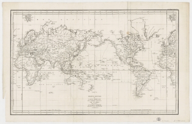
Mappemonde ou Carte réduite des parties connues du globe pour servir au voyage de La Pérouse, fait dans les années 1785, 86, 87, et 88.
|
|
Other Title:
|
Carte réduite des parties connues du globe pour servir au voyage de La Pérouse, fait dans les années 1785, 86, 87, et 88
|
|
Contributor:
|
La Pérouse, Jean-François de Galaup, comte de, 1741-1788, cartographer
|
|
Contributor:
|
Imprimerie de la République (France), 1795-1804, printer
|
|
Category:
|
Sea Charts
|
|
Type:
|
Printed
|
|
Language:
|
French
|
|
Create Year:
|
1797
|
|
Format:
|
JPEG 25167 × 16248, 82.5MB
|
|
Page No.:
|
1
|
|
Scale:
|
[ca. 1:50,000,000] (W 180⁰--E 180⁰/N 81⁰--S 71⁰).
|
|
Physical Map Dimension (cm):
|
60 x 96 cm
|
|
Note:
|
This map was made by Jean François de Galaup, count of La Pérouse, a French naval officer and explorer. Promoted captain of the navy, he was chosen by the Charles Eugène Gabriel de La Croix, Marquis de Castries, Minister of Marine (1727-1801) and by king Louis XVI (1754-1793) to lead an expedition around the world aimed at completing the discoveries of James Cook (1728-1779) in the Pacific Ocean. He crossed the Pacific Ocean arrived in Macau, via the Philippines he then sailed north to the Kamchatka Peninsula. The map displays the most up to date cartography, especially along the North West Coast of America, North East Coast of Asia, Australia, New Zealand and the Pacific. La Perouse's voyage is perhaps second only to James Cook in their impact on cartographic knowledge and discoveries in the Pacific Ocean in the second half of the 18th century. When La Pérouse arrived at Macau, he sold the furs acquired in Alaska and visited Bernardo Aleixo de Lemos e Faria (1754-1826) who was the Governor of Macau.
|
|
Note:
|
Original is a copperplate printed map published on 'Atlas du voyage de La Pérouse', 55 x 89 cm.
|
|
Note:
|
Prime Meridian: Paris.
|
|
Note:
|
Map with graticule.
|
|
Note:
|
The four borders of the map with latitude and longitude lines.
|
|
Note:
|
Map outlined in double fillet.
|
|
Note:
|
Macao in World maps.
|
|
Note:
|
Macao in routes.
|
|
Subject:
|
Voyages around the world
|
|
Geographic Area:
|
World
|
|
Geographic Area:
|
Europe
|
|
Geographic Area:
|
Africa
|
|
Geographic Area:
|
Asia
|
|
Geographic Area:
|
Oceania
|
|
Geographic Area:
|
North America
|
|
Geographic Area:
|
Central America
|
|
Geographic Area:
|
South America
|
|
Relation Note:
|
N.º 1
|
|
Pub Title:
|
Atlas du voyage de La Pérouse
|
|
Pub Author:
|
La Pérouse, Jean-François de Galaup, comte de, 1741-1788
|
|
Pub Year:
|
1797
|
|
Pub location:
|
Paris
|
|
Provenance:
|
Harvard College Library
|
|
Provenance:
|
http://id.lib.harvard.edu/alma/990095091550203941/catalog
|
|
Provenance Call No.:
|
G3200 1797 .L3 oversize
|
|
MUST holding:
|
https://must.primo.exlibrisgroup.com/permalink/853MUST_INST/171sgkf/alma991000042679705076
|