Detail View: Old Maps Collection: Carte réduite de l'ocean oriental depuis le Cap de Bonne Espérance jusqu'à l'isle Formose
|
Barcode:
|
4687820500444
|
|
Title:
|
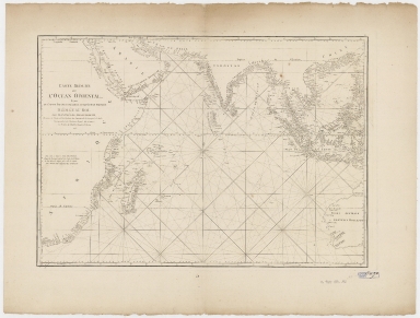
Carte réduite de l'ocean oriental depuis le Cap de Bonne Espérance jusqu'à l'isle Formose
|
|
Original Title:
|
Carte réduite de l'ocean oriental depuis le Cap de Bonne Espérance jusqu'à l'isle Formose
|
|
Contributor:
|
Après de Mannevillette, Jean-Baptiste-Nicolas-Denis d', 1707-1780
|
|
Category:
|
Sea Charts
|
|
Type:
|
Printed
|
|
Language:
|
French
|
|
Create Year:
|
1775
|
|
Format:
|
JPEG, 21297 × 16145, 86.4MB
|
|
Scale:
|
approximately 1:17,000,000 (E 17°42ʹ00ʺ--E 124°51ʹ00ʺ/N 32°38ʹ00ʺ--S 37°39ʹ00ʺ)
|
|
Physical Map Dimension (cm):
|
48.8 × 69.5
|
|
Note:
|
Shows Indian Ocean, including Red Sea, Persian Gulf and the Bay of Bengal. Shows rhumb lines.
|
|
Note:
|
Macao and the surrounding islands were depicted in this map.
|
|
Note:
|
Macao and its Surroundings
|
|
Note:
|
Macao in Routes
|
|
Note:
|
Macao in Asia Maps
|
|
Subject:
|
Coasts
|
|
Subject:
|
Nautical charts
|
|
Geographic Area:
|
Indian Ocean
|
|
Geographic Area:
|
Southeast Asia
|
|
Relation Note:
|
Plate 9 from: Le Neptune oriental, dedie au roi /par M. d'Apres de Mannevillette. Paris ; Brest [France] : Chez Demonville, Imprimeur-Libraire de l'Academie Francoise ; Chez Malassis, Imprimeur-Libraire de la Marine, 1775.
|
|
Pub Title:
|
Le Neptune oriental, dedie au roi
|
|
Pub Author:
|
Après de Mannevillette, Jean-Baptiste-Nicolas-Denis d’, 1707-1780
|
|
Pub Year:
|
[1781-1789]
|
|
Pub location:
|
Paris
|
|
Provenance:
|
Harvard Map Collection - Harvard College Library
|