Detail View: Old Maps Collection: Chinese empire, and Japan
|
Barcode:
|
4687820500442
|
|
Title:
|
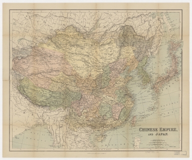
Chinese empire, and Japan
|
|
Original Title:
|
Chinese empire, and Japan
|
|
Contributor:
|
George Philip & Son
|
|
Category:
|
General Maps
|
|
Type:
|
Printed
|
|
Language:
|
English
|
|
Create Year:
|
1890-1898
|
|
Format:
|
JPEG, 16000 × 13350, 75.6MB
|
|
Scale:
|
ca. 1:10,000,000 (E 73°29ʹ00ʺ--E 147°15ʹ00ʺ/N 54°44ʹ00ʺ--N 15°07ʹ00ʺ).
|
|
Physical Map Dimension (cm):
|
48.1 × 61
|
|
Note:
|
Prime meridian: Greenwich. Also shows railways open, British railway concessions in China, projected railways, treaty ports and submarine cable. The title on the cover reads: Philips' special map of the Chinese Empire and Japan, showing the recent railway concessions.
|
|
Note:
|
Macao and the surrounding islands were depicted in this map.
|
|
Note:
|
Macao in China Maps
|
|
Subject:
|
Railroads
|
|
Geographic Area:
|
China
|
|
Geographic Area:
|
Japan
|
|
Geographic Area:
|
Tibet Autonomous Region (China)
|
|
Pub Year:
|
[1890-1898]
|
|
Pub location:
|
London
|
|
Provenance:
|
Harvard Map Collection - Harvard College Library
|