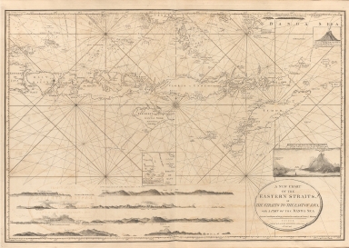
Detail View: Old Maps Collection: A new chart of the Eastern Straits or the straits to the east of Java with a part of the Banda Sea
|
Barcode:
|
4687820500440
|
|
Title:
|
A new chart of the Eastern Straits or the straits to the east of Java with a part of the Banda Sea
|
|
Original Title:
|
A new chart of the Eastern Straits or the straits to the east of Java with a part of the Banda Sea
|
|
Contributor:
|
Williams, Robert
|
|
Category:
|
Sea Charts
|
|
Type:
|
Printed
|
|
Language:
|
English
|
|
Create Year:
|
1798
|
|
Format:
|
JPEG, 10665 × 7592, 95.1MB
|
|
Scale:
|
[ca. 1:1,800,000]
|
|
Physical Map Dimension (cm):
|
58 × 86
|
|
Note:
|
Insets: Straits of Sapy -- Entrance of the straits or gut of Larantooca from the northward by Captn. Robt. Williams 1797 -- A view of the burning island in the Banda Sea. "Corrected and improved, chiefly from the observations of Captn. R. Williams."
|
|
Subject:
|
Nautical charts
|
|
Subject:
|
Straits
|
|
Subject:
|
Islands
|
|
Geographic Area:
|
Indonesia
|
|
Pub Title:
|
The complete East-India pilot, or oriental navigator ... chiefly composed from actual surveys and draughts communicated by experienced officers of The East-India Company and from the French Neptune oriental
|
|
Pub Author:
|
Après de Mannevillette, Jean-Baptiste-Nicolas-Denis d’, 1707-1780
|
|
Pub Year:
|
1800
|
|
Pub location:
|
London
|
|
Provenance:
|
Harvard Map Collection - Harvard College Library
|