Detail View: Old Maps Collection: Chart of Choo Keang or Canton river
|
Barcode:
|
4687820500439
|
|
Title:
|
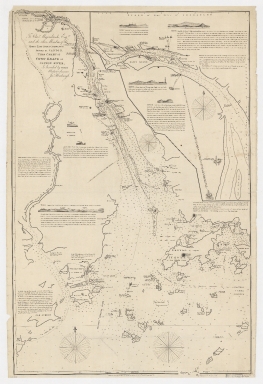
Chart of Choo Keang or Canton river
|
|
Original Title:
|
To Chas. Majoribanks esq.re and the other members of the hon.ble East India Company's factory at Canton, this Chart of Choo Keang or Canton river, is inscribed ... by James Horsburgh.
|
|
Contributor:
|
Horsburgh, James
|
|
Category:
|
Thematic Maps
|
|
Type:
|
Printed
|
|
Language:
|
English
|
|
Create Year:
|
1831
|
|
Format:
|
JPEG, 16654 × 24295, 83.5MB
|
|
Scale:
|
Scale not given
|
|
Physical Map Dimension (cm):
|
96 × 62
|
|
Note:
|
Greenwich meridian. Includes inset of Pearl River segment from the Whampoa pagoda to See Chow (Small pagoda).
|
|
Note:
|
Macao and the surrounding islands were depicted in this map.
|
|
Note:
|
局部圖
|
|
Note:
|
Macao in Routes
|
|
Note:
|
Macao and its Surroundings
|
|
Subject:
|
River surveys
|
|
Geographic Area:
|
Pearl River (China)
|
|
Geographic Area:
|
Pearl River Delta (China)
|
|
Geographic Area:
|
Macao (China)
|
|
Pub Year:
|
1831
|
|
Pub location:
|
[London]
|
|
Provenance:
|
Harvard Map Collection - Harvard College Library
|
|
MUST holding:
|
http://10.20.100.239/record=b1394913
|