Detail View: Old Maps Collection: Stanford's map of Eastern China, Japan and Korea : 1898.
|
Barcode:
|
3687800354469K
|
|
Title:
|
Stanford's map of Eastern China, Japan and Korea : 1898.
|
|
Other Title:
|
Map of Eastern China, Japan and Korea
|
|
Other Title:
|
Korea.
|
|
Contributor:
|
Edward Stanford Ltd., author, publisher
|
|
Category:
|
General Maps
|
|
Type:
|
Printed
|
|
Language:
|
English
|
|
Create Year:
|
1898
|
|
Format:
|
JPEG 13733 x 16624, 77.2MB
|
|
Scale:
|
[1:6,969,600] (E 104°--E 144°/N 48°--N 12°).
|
|
Physical Map Dimension (cm):
|
63 x 51 cm, on sheet 73 x 57 cm
|
|
Note:
|
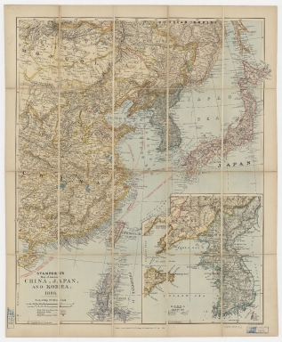
Edward Stanford (1827-1904) was a prominent British mapmaker and publisher. He was member of the Royal Geographical Society and in 1857 founded his namesake Geographical Establishment with Trelawney William Saunders (1821-1910) and Alexander Keith Johnston (1804-1871) as engravers. Thereafter, Stanford was known for his “library maps”, particularly those of Africa and Asia. By 1881 he employed 87 people at his premises, the business survived him, and the Stanford’s shop is still a prominent London landmark today. This is a map of the Theater of War in China, Korea, Japan, extending to the Philippines. Focusing on the legend one can see the map is obviously political with 'Treaty ports' underlined in red and the 'Proposed Treaty ports' of 1898 in a red circle. The railway lines and submarine cables are also depicted, as are the The Great Wall, Barrier of Stakes or Palisade, among other boundaries. On the bottom right corner of the map there is a large inset of Korea with 'main roads' and 'telegraphs' marked.
|
|
Note:
|
Inset 1: Korea. - Scale indeterminable. - 26 x 25 cm.
|
|
Note:
|
Original is a printed map, 62 x 50 cm, folded in cover to 18 x 12 cm.
|
|
Note:
|
On the right bottom corner of the map: "Stanford's Geog.l Estab.t London".
|
|
Note:
|
Double scale line underneath the title on the left bottom corner of the map.
|
|
Note:
|
Relief shown by hachures.
|
|
Note:
|
Map and inset with graticule.
|
|
Note:
|
Different countries outlined in different colors.
|
|
Note:
|
The four borders of the map with latitude and longitude lines.
|
|
Note:
|
Map outlined in double fillet.
|
|
Note:
|
Macao in East Indies maps.
|
|
Note:
|
Macao in routes.
|
|
Subject:
|
Coasts
|
|
Geographic Area:
|
East Asia
|
|
Geographic Area:
|
Japan
|
|
Geographic Area:
|
Korea
|
|
Geographic Area:
|
China
|
|
Geographic Area:
|
Taiwan
|
|
Geographic Area:
|
Mongolia
|
|
Geographic Area:
|
Philippines
|
|
Provenance:
|
Harvard College Library
|
|
Provenance:
|
http://id.lib.harvard.edu/alma/990138220820203941/catalog
|
|
Provenance Call No.:
|
G7800 1898 .E3
|
|
MUST holding:
|
https://must.primo.exlibrisgroup.com/permalink/853MUST_INST/171sgkf/alma991002998948905076
|