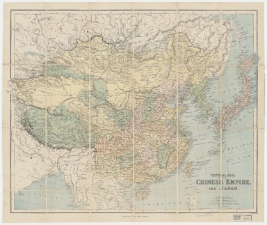
Detail View: Old Maps Collection: Central Asia with the Chinese Empire, and Japan
|
Barcode:
|
4687820500425
|
|
Title:
|
Central Asia with the Chinese Empire, and Japan
|
|
Original Title:
|
Central Asia with the Chinese Empire, and Japan
|
|
Contributor:
|
George Philip & Son
|
|
Category:
|
General Maps
|
|
Type:
|
Printed
|
|
Language:
|
English
|
|
Create Year:
|
1870-1879?
|
|
Format:
|
JPEG, 15883 × 13362, 74.5MB
|
|
Scale:
|
ca. 1:10,000,000 (E 75°15ʹ00ʺ--E 148°18ʹ00ʺ/N 56°37ʹ00ʺ--N 14°00ʹ00ʺ)
|
|
Physical Map Dimension (cm):
|
49 × 65
|
|
Note:
|
Jacket title: Philip’s authentic map of China. Prime meridian: Greenwich.
|
|
Note:
|
Macao and the surrounding islands were depicted in this map.
|
|
Note:
|
Macao in China Maps
|
|
Geographic Area:
|
China
|
|
Pub Year:
|
[between 1870 and 1879?]
|
|
Pub location:
|
London
|
|
Provenance:
|
Harvard Map Collection - Harvard College Library
|
|
MUST holding:
|
http://10.20.100.239/record=b1352178
|